In Search of Perfection – A Traverse of Liathach

It’s a day that will probably be seared into my memory till the day I die, a day which sparked a fire of enthusiasm and passion for adventure; the day I fell in love with mountains, the Highlands, and winter climbing. The moment of Damascene conversion, when I decided that I wanted to spend my life exploring mountains occurred during climbing the last few meters of a steep snowy grade I gully on the north side of Liathach, a sandstone colossus in Torridon.

torridon-4

A perfect winter day.

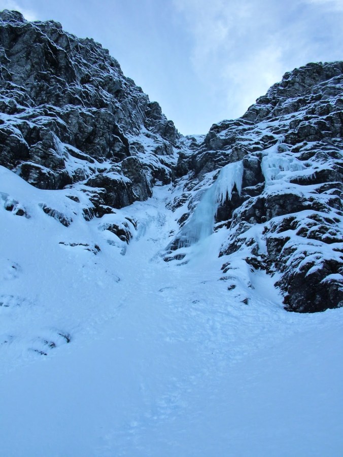
It was all a new experience, the excitement of climbing the firm neve with walls of back rimed rock towering above on either side, working slowly up, towards a clean, sharp dichotomy, as the white of the gully met a slot of blue sky. Those final few meters were a stunning contrast, emerging from the narrow defile of the gully onto the summit ridge and into an immense feeling of space. The Highlands were spread out before me, under a brilliant blue sky snow capped mountains stretched away to the horizon in all directions, great towering castles of Torridian sandstone steep, and seemingly impregnable, yet here I was standing on a gossamer thin ridge, dancing above the Earth as the south face of Liathach fell away steeply into the valley.

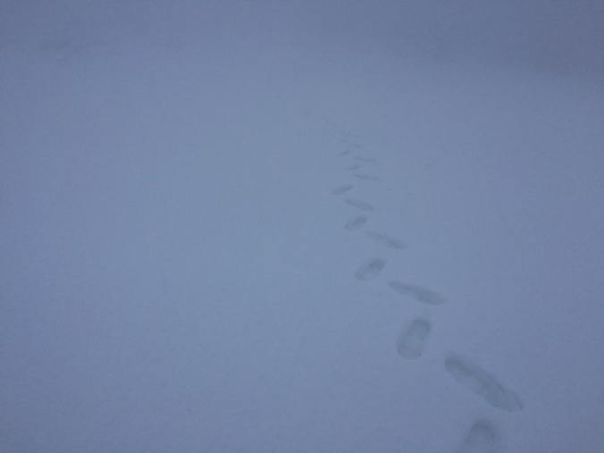
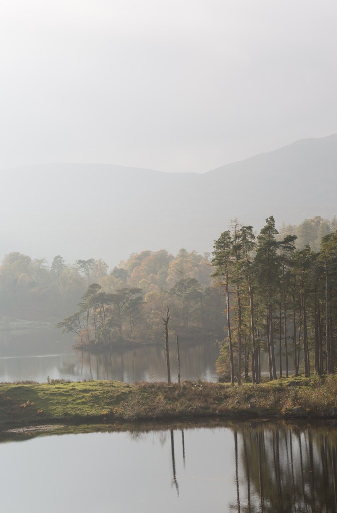
Although now fifteen years ago I remember it vividly, perhaps it’s all the sharper because I have no photographs of the day to dull the ardor for the memory, nothing to suggest that in reality perhaps the sky was not quite so blue, or the snow not quite so brilliantly white. For a first experience of winter climbing I could not have asked for more, yet I was to learn quickly that such days are rare, the Highlands in winter are fickle, and for every perfect day the great engines of ocean and atmosphere that drive our weather deal many Jokers  from their pack.

torridon-6

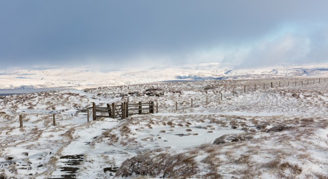
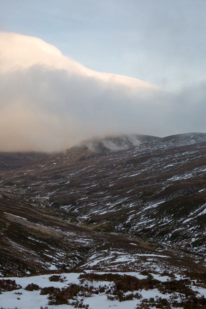
Beinn Alligin and Loch Torridon

That day in 2002 we did not actually climb either of Liathach’s two Munro summits Mullach an Rathian and Spidean a’Choire Leith, but traversed the ridge to the eastern top of Stuc a’Choire Dhuibh Bhig before retreating back down the gully, the main summit a step too far for a party of novices on their first trip and shattered from fighting through deep snow lower down.

Needless to say Liathach was unfinished business to me, I have visited Torridon a few times since, drawn by the beautiful triptych of Liathach, Beinn Eighe, and Beinn Alligin. The twin munro summits of the latter two peaks fell at intervals over the years, but never under conditions anything like those I remembered from that first love, sometimes I had snow and mist, sometimes it was snow and rain, but never was there a hint of weather that could do justice to that memory I held so close to my heart.

torridon-9

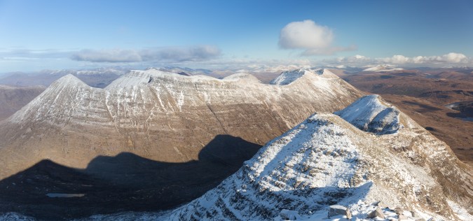
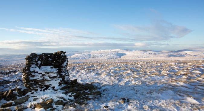
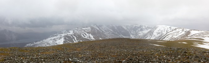
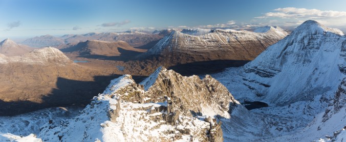
Beinn Eighe, beyond Liathach’s summit ridge. The eastern top visited in 2002 is at last

I guess you can sometimes hold your dreams too tightly, to the extent you snuff them out whilst waiting for them to be perfect.  Fifteen years of trying to line up weekends, weather, snow, and other commitments can make you begin to ask if the stars will align again, yet still that memory is so strong that you can’t risk sullying it with disappointment. It’s a catch -22 which make it easy to find something not quite right and a reason to postpone the trip.

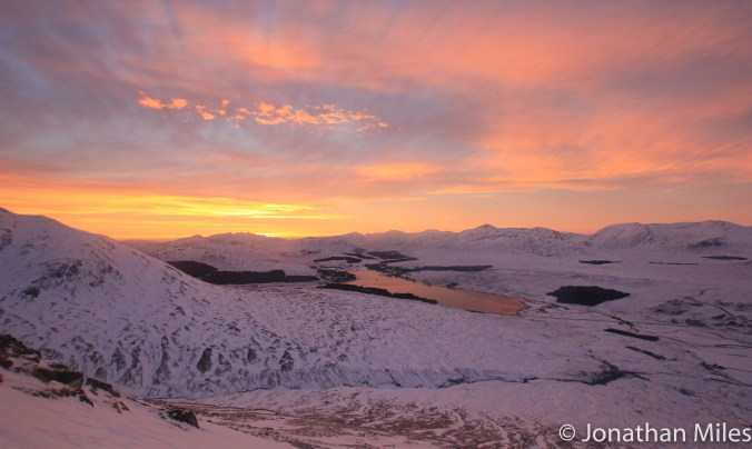
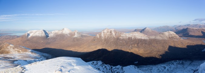
This month I slew that dragon. Taking a chance on a good but not perfect forecast, excepting the risk of disappointment; and, in traversing Liathach under brilliant blue skies had one of my best days in the hills. The snow may not have been as deep as in 2002 but as I climbed onto the ridge just below Mullach an Rathain the great expanse of Wester Ross, hidden till the last few steps was revealed rolling away towards to the sea. In that instant, something inside me leapt with joy just as it had those 15 years ago.

There are other beautiful moments in time, you just have to go out and find them.

torridon

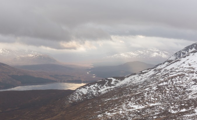
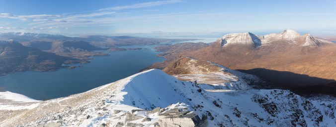
Beinn Alligin (left) and Beinn Dearg from just below the summit


Mam Tor Microadventure

Slightly disappointed in myself having made it to February and not camped out overnight yet, I took advantage of a good weekend forecast to head to the Peak District with the hope of spending the night on top go Mam Tor. The forecast was for fog in the morning and I was had my fingers crossed for an inversion.

mam-tor-camp

Early Morning Cuppa

Most people think I’m slightly mad for camping out in winter, but I really enjoy it, it adds a little spice to the adventure, and also there is the satisfaction of brewing up on a cold crisp morning whilst feeling warm and refreshed from cold night air! After experimenting for ten plus years I’ve made most of the mistakes, forgetting my sleeping mat during a winter climbing trip to Pembroke was the worst, a horrible cold night with very little sleep ensued even though I had a bag rated to minus twenty! A good bag is certainly worth the investment, I bought mine at least a decade ago and its still toasty, and coupled with an Exped down mat I’ve never been cold even sleeping in just pants.

mam-for-sunrise-5

Loose Hill

Mam Tor was particularly exciting spot to sleep as I was also camped in the remains of an iron age fort which covers the summit of the hill. I pitched up somewhere within the ancient ditches for the fort, now little more than furrows in the landscape but still substantial enough to offer a bit of shelter, although these days from the wind rather than the neighbouring tribe on the warpath. I found it inspiring to go to sleep thinking about all the others through the millennia who have called this hill home for a night, what were they doing there and what did the landscape around them look like?

mam-for-sunrise-4

Looking towards Hope and Castleton

Come morning the cloud inversion didn’t happen but I did set some sunrise photos, although shooting into the sun was a bit of a challenge I’m not used to. Not sure there is a stunning image amongst them but thats not the point.

mam-for-sunrise-3

The cement works at Hope

First Signs of Winter on Great Shunner Fell

Even though we are half way through January winter has been particularly elusive so far this year. Sure, its been cold and damp, but those clear frosty mornings when the world is touched with white have been conspicuously absent. Last week with the media running about like headless chickens and talking about the incoming Snowmaggedon I admit I went to bed excited that finally I would be able to dust off the skis or axes.

The winter sport enthusiast is however used to disappointment; rather like he who chases the rainbow, the ice and snow always appear to be just out of reach, like a spectre who is due to arrive tomorrow, or who left yesterday, never quite overlapping which the hear and now. Snowmageddon did not result in a thick blanket of pure white powder across the landscape, but the hills did look to have a light dusting, and although my plans to ski tour had to be left to another day, the bright blue skies promised a good winter day was there for the taking.

I chose Great Shunner Fell in the Yorkshire Dales a rounded whale of a mountain between Wensleydale and Swaledale just west of the Buttertubs Pass. The Pennine Way runs over the summit and I followed this out of Hardraw (home to Hardraw Force, Englands highest unbroken waterfall) up a track coated in a sheet of ice and frozen snow which was actually surprisingly grippy.

gt-shunner

Looking across upper Wensleydale, the flat to of Ingleborough can just be seen in the distance. 

Soon you leave the last dry stone wall behind and head out onto the open moor climbing up a very broad ridge of grass and heather, the gradient is very gently rising the five hundred meters to the summit over 8 kilometres. The views behind me were fantastic, upper Wensleydale coated in a heavy dusting of snow, the black dry stone walls standing out starkly against the white fields they enclosed. Across the other side of the valley, Fleet Moss, the highest road in Yorkshire stood out under a blue sky and brilliant sun; the light glinting off its frozen surface, forming a thin line, like a river of molten sliver, draped over the hills ran from the moorland dropping steeply into the dale below.

Climbing higher Ingleborough, easily recognisable from its flat topped profile appeared in the distance, shrugging clouds from its shoulders to bask in the sun. The rays of the sun did little to combat a bitter wind which sapped the warmth from exposed skin, and had clearly spent many hours sculpting the covering of snow into waves and ridges across the moor.

The ridge appeared to go on forever as kilometre after kilometre slowly ticked by, the summit shelter only revealing itself during the last five hundred meters or so. From the summit the view were expansive across much of the Dales and beyond, Ribblesdale, Swaledale, and Wensleydale all stretching away in a panorama of snow capped hills and high moorland.

gt-shunner-2

The high moor just below the summit with Swaledale beyond

gt-shunner-4

Looking north from the summit shelter 

After a warming cup of coffee I turned to descend east towards the Buttertubs Pass, following a helpful fence line though the pathless terrain over Little Shunner Fell. This walk is one  of those its probably best to climb in winter, its vast bogs, sworn enemies of your boots frozen in the cold, crisp air. Although the snow is thin I follow ski tracks from just below the summit right down to the road, which with a good covering would make a nice little run.

Rather than follow the road back to Hardraw, its only a short addition to the route to cross the road and climb up Lovely Seat; again I was aided by a handrail to the summit by a well placed fence line! As the name suggests once the top is reached one can sit down and enjoy the view back to Great Shunner fell from a large stone chair. From here the broad scale of the hill becomes apparent, the southern ridge which I made my way up earlier stretches away dropping very slowly towards Wensleydale looking every inch of its eight kilometres.

Now I left the friendly handrails behind and took a baring across the open moorland for just over a kilometre, heading for Shivery Gill which I followed swiftly down to the road. After following this for a further kilometre I joined a footpath back to Hardwaw just after the road drops steely down a 20% ramp now famous from the iconic scenes in 2014 when the Tour de France fought its way through a wall of spectators here.

As I write this the snow has vanished, hopefully only temporarily, for it would be nice to get the skis out on those hills. Fingers crossed.

gt-shunner-3

Great Shunner Fell from Lovely Seat


Not Quite Winter on Carn Liath and Beinn Udlamain

Those few days between Christmas and New Year are often a holding pattern between the consumption of too much food and the consumption of too much alcohol. As the days are mandatory holidays for me, and I had just about worked through the myriad of snacks that accompany the festive celebrations it seamed like a good idea to head somewhere for a few days in the hills to address the calories in the bank so to speak.

I’m particularly inspired by climbing and walking in Scotland in winter, drawn by the thought of peaks and ridges capped with crisp snow set against a blue sky. As someone who lives 400 miles away from the Highlands I tend to view weather forecasts around my windows of opportunity in my work calendar through slightly Quixotic glasses and possibly myopic fashion, always hoping conditions will be slightly better than advised!

By Boxing Day however any optimism I may have held about a few days on the west coast had been battered into submission by storms Barbara and Conor and my hope of a to north looked to be fading. Looking for a straw to grab a hold of a few pictures glimpsed on Twitter of snow settling around Loch Morlich convinced me that the Cairngorms could allow me to snatch a few days wintering before heading back to work.

blog4

Looking for the summit

Four hundred miles later and it was clear that the skis, crampons, and axes were going to stay in the car as temperatures rose rapidly to high single digits, bringing wind and cloud to dominate the forecasts. Rather than use my time to slog up a gully full of soft rapidly melting snow I decided to use my time to visit two  Munros I’ve missed during previous trips that would otherwise get overlooked as I slowly work through the remaining 200 on my to do list.

Beinn Udlamain (1011m) is one of four rounded hills that lie just west of the A9 at the Drumochter summit, all four are a reasonably reliable ski tour with snow often down to road level and I had been able to pick three of them off like that during earlier trips. Beinn Udlamain lies farthest from the road and had therefore been left till last. In good weather experienced ski tourers (which I’m not) could easily link together at least two and possibly all the summits without too much difficulty.

With a light pack, not requiring much usual winter kit, I followed the landrover track from the A9 up Coire Dhomhain, the head of which was lost in a opaque  ceiling of grey cloud. Reaching an obvious stream coming down from the coll between Beinn Udlamain and  A’ Mharconaich I turned up a stiff climb over grass and hether but very little snow.  Higher up there was a covering of the white stuff, which in the cloud brought a virtual whiteout and disconcerting slog up into nothing.

Finally the seeming interminable white slope gave way to a rounded broad ridge clear of snow which I could follow via a couple of doglegs (and well spaced old fence posts) to the summit after just over a kilometre.

15747412_10100427264243069_3876748215602161377_n

One of those days!

blog2

Cloud banks above the Sow of Atholl

With the summit shrouded in grey mists Beinn Udlamain lived up to one translation of its name, the “gloomy mountain”; although to be fair to it, in climbing its three neighbours Geal-chàrn, Sgairneach Mhòr and A’ Mharconaich I’ve never been able to see more than about 100m on any of the summits missing what must be good views across to Ben Alder and Loch Erict.

The second peak I picked off was Carn Liath which lies above Loch Laggan and is often climbed with (and probably overshadowed by) Creag Meagaidh a fantastic mountain with, in my opinion the finest winter coire in Scotland in Coire Ardair.

The route (faint path) left the excellent path to the coire just before it enters the woods and climbs steeply up onto the shoulder of Na Cnapanan. I say path in the loosest possible terms as for its lower half it was little more than a stream weaving its way through holders and trees! Higher up things improved and from the shoulder the gradient relents giving an easy climb up to the main summit all the while offering a fantastic view across to Coire Ardair across whose headwall you can trace the classic steep climbing gullies of the Post Face .

Today these looked a little forlorn, thin and surrounded by black rock with only Easy and Raeburn’s Gully looking climbable and even then probably a slog through soft snow. Even looking forlorn though I still find the sight inspiring there are some brilliant days to be had here.

blog3

Coire Ardair

Creag Meagaidh has pride of place as one of my most frustrating mountains; possibly like nowhere else in Scotland it balances on a knife-edge between not enough snow and lethally too much snow. The vast plateau behind the coire collects huge volumes of the stuff which when moved about by easterly winds makes it an avalanche black spot and home to some colossal cornices.

A few year back in good conditions I remember seeing some massive old avalanche debris whilst climbing up through the notch in the back of the coire known as the Window. Its not somewhere I want to venture on a marginal forecast from SAIS.

Hopefully this will be the first of a few days in Scotland this year, I’m hoping to focus on ski touring with quite a few munros lined up should conditions click.  That said if I can grab a few easy gullies later in the season that would be a bonus too!

blog3-2

Honister Microadventure

A Honister Microadventure… or how I went failed to find Warnscale Head Bothy.

There are very few bothies (buildings left open as simple overnight shelters) in England and most of these are in and around Kielder Forest in Northumberland. A couple exist in the Lakes though, one above Buttermere on Warnscale Head, which I wanted to visit as it’s a fantastic viewpoint down the valley and a great location for some photography.

Originally built as part of the slate mines which delve and burrow through the hills in this part of the Lakes,  the bothy is tiny, sleeping only three at a push, so as I left my car at Honister I threw my tent flysheet in my pack just in case.

honister-no-logo-7

Dubs Hut and Haystacks

 
Dusk was fast approaching as I climbed up the old incline to Dubs Quarry where a second Lakes bothy Dubs Hut sits nestled surrounded by scree and slate waste. Lights in the window showed the bothy was occupied for the night; I droped down towards Warnscale Head with Haystacks rapidly disappearing into the gloom towards where I thought the bothy was. Within 10 minutes or so the light and completely gone and I realised I had rather stupidly not bothered to get a grid reference for the hut so decided to find a patch of grass and pitch up for the night.


honister-no-logo

Morning all!

The spot I chose proved to be just about the least sheltered point I could have picked and the tent fabric snapped and rattled in the wind through the night, but cocooned in my bag I was warm as toast despite the temperature falling close to if not past freezing. Come morning I had a fantastic view down the valley but with the sun rising at my back behind the mountains the light was a little flat.

It was bitterly cold and the wind was still whipping past the tent so it was good to get moving up towards Haystacks to explore a view more photographic opportunities. The higher fells were still covered with snow which crunched satis-factually under my boots, the first snows of a new winter and hopefully one with many adventures to come.

Innominate tarn and Haystacks summit tarn were both frozen solid and offered some nice compositions, but taking any good photos proved a challenge as the low sun played havoc casting long dark shadows or brilliant glare across the landscape. Despite this is was good to be out and at least I can come back again and find the bothy in time for sunset next time.

honister-no-logo-3

Ennerdale is shrouded in shadow from a low inter sun between Pillar and High Stile

honister-no-logo-6

Innominate Tarn and Pillar

honister-no-logo-5

Innominate Tarn and Great Gable

honister-no-logo-2

From Wasdale Head down to Buttermere

honister-no-logo-4

Innominate Tarn from high on Haystacks

Buttermere Microadventure

With the last colours of autumn fading I wanted to get out with the camera and try and capture some good images in the Lakes. Saturday was a bit overcast and made for poor images but I hoped Sunday would be better and if not the idea was to find a waterfall which is always a good fall back option when conditions crap out.

I camped Saturday night just above Buttermere as I wanted to try and take the classic view of the lake familiar from many others photographs. Its an unoriginal but great view, trees reflected in the still waters of the lake as the sun rises over the peak of Haystacks in the background.

bbb-1

In the end I was not disappointed, the overcast sky lit up well in the morning and I took some lovely images before the sun rose above the clouds and the light went flat. With big landscapes shots now obviously out for the day I walked up to explore Scale Force, the highest waterfall in the Lakes with a tremendous main drop go 35m down a narrow gorge. I took some nice images and got excited with the though of how the route would look in winter, apparently it form a good grade five which I can possibly persuade someone to drag me up.

bbb-2

I finished the day with a hike up to Red Pike whose summit was lost in cloud and being beaten by a bitter wind, before dropping steeply back to Buttermere via Bleberry Tarn. My legs certainly felt a little out of condition, not a good sign before what I hope to be a big winter of ski touring and winter climbing. I’ve spent too much time recently visiting easily accessible viewpoints with my camera rather than going for a big walk with my camera and taking what comes. Best get training…


Dordogne Canoe Adventure

From my old archive a river adventure.

A flash of lightning rents the rapidly darkening sky, followed seconds later by a crash of booming rolling thunder as masses of superheated air slam together in the heavens. The rain is torrential making the surface of the river come alive with ten thousand dancing sprites. Sitting in the canoes as our little caravan paddles down the river we curse our luck that we have driven 800 miles and found the very same rain we had hoped to leave in the UK. Still it’s exciting, I love the primeval nature of a thunderstorm; the raw energy, power, and way it displays the forces of nature so vividly over man, yet also makes me feel more connected to a landscape when I’m sat in the middle of it.

Dordogne-1.jpg

They go this way up right?


Today is the fist day on the river for our team of seven, for a couple of hours now we’ve been getting used to our canoes and vainly struggling to paddle them in a straight line. The plan is to spend six days paddling down the Dordogne River between the small french towns of Argentat and Vitrac, a distance of 110km, each night camping by the river and enjoying the local cheese, wine, and plenty of banter. Like all good plans we jump straight in at the deep end with day one as the biggest day with 27km to cover before we reach landfall in Beaulieu. The company we have hired the boats from offer both self supported and luggage relay, we have opted for the latter although this does limit us to staying in official campsites rather than wild camping on the riverbank.


The rivers meanders it’s was through green woodlands interspersed with fields of rape and grass. The paddling itself is nothing technical, mostly flat water with the occasional small rapids to negotiate which add a bit of spice the journey, and a bit of water to the interior of the canoe. 

Dordogne-2.jpg

Just about getting the hang of this straight line thing.

The storm is short but violent, once the rain slows the water is brilliantly clear and we spot fish darting about trying to keep within the shadow of the canoe. The sun remembers it’s in the south of France begins to burn off the cloud, and the river begins to steam in the humidity, swallows appear from the trees darting and skimming just above the water buzzing the boat like miniature dogfighting aeroplanes as they feed on the insects that hover just above the surface. Brilliant cobalt blue dragon flies hover along side us on incredibly delicate gossamer thin wings. 


After a little practice the canoes turn out to be easy to steer, the paddler in the from seat concentrating on delivering the power whilst the rear seat also deals with the steering with some basic rudder skills. For much of the time the river flows through treelined country, and because France is much more sparsely populated than the UK the trip has a much more wild feel than I think any river in the UK (even Scotland) would. We break the day and journey up by rafting up the boats together for a brew or a swim,  it’s incredibly tranquil and relaxing, just drifting along with the current feet trailing in the water.

Dordogne-9.jpg

A bit of drama is saved till the end of the day when paddling into Beaulieu we have to negotiate a small canoe slide just before the pull out. When Gina and Chris come down the shoot they get caught by the stopper at the base which spins them through 90 degrees into the bank and then bounces them out into mid stream. Unfortunately before they can get the canoe straightened the current takes it into the support for a bridge over the river causing the boat to flip over and we have our first and fortunately only capsize of the trip.

Dordogne-3.jpg

Downhill from here!

I attempt to spring into rescue mode by completely failing to paddle upstream against the current and nearly capsize my own boat which I now realise is dangerously full of rain water. Fortunately the others are much more organised in effecting a rescue, getting the guys and their boat to the shore and helping get it drained.

Once at the campsite we then realise we have made a serious mistake, our luggage hasn’t yet arrived and were sat in wet clothes having not thought to take a spare set with up on the boats (because it’s hot in the south of France in summer, No?). Copious amounts of tea, and strongly alcoholic coffee go some way to improving the situation, although we are very happy when about an hour later our kit arrives and we can jump in the showers and warm ourselves up properly.

Dordogne-5.jpg

4 season mountain tent is the south of France in Summer

Dordogne-16.jpg

Enter a caption

Dordogne-4.jpg

The best day of the trip was when the river passed through a steep gorge. Geologists claim to comprehend deep time; I don’t believe them. Deep time is the early period of the Earth’s life and were talking billions of years ago here; is the human brain is truly capable of comprehending 5 million years, never mind 500 million let alone 5 billion? I think not, its so unfathomably outside the frame of reference of our lives so as to be almost meaningless. The gorge through which we paddled offered a glimpse into the fathomless age of the earth, a hint of the almost unimaginable time required to build and then tear down mountains, quite fascinating and deeply beautiful. 

We are in limestone country, layer upon layer of white and grey rock is piled up around us, through  which the river has calved its remorseless way. I’m not a geologist but try and understand the basics given it’s the controlling force in the landscapes that I love, the sculptor who created the places where I climb, paddle, and ride.

 dordogne-12dordogne-11

The spectacular limestone cliffs which line the river tower up to fifty meters above the water which has sculpted caves, pinnacles, prows, and curves in to the cliff face. Topped with trees, and climbing plants, long drapes of vines hang down the faces and the nooks and ledges provide a home for birds, and insects.

Given the scale of the cliffs it’s hard to imagine that they were formed under an ancient tropical sea from billions of dead coral plants laid down over countless generations which were slowly converted into limestone. We are already dealing with a staggering amount of time just to lay down 50m worth of limestone but its only part of the story in creating this landscape. Plate tectonics carried the young rock across the surface of the planet, and then inch by inch lifted them up from the seabed into the sun and atmosphere. Then slowly rain goes to work with its chisel,  the drops of water are very slightly acidic from carbon dioxide in the atmosphere, capable of dissolving minute quantities of rock which over time allows the water to devour the rock into the myriad of shapes we see today. 

It’s a neat closing of a circle the coral life of the past now provides the ledges and cracks in which the life of today flourishes. Indeed I think most limestone here is less than 300 million years old which hardly qualifies as deep time, but more like yesterday compared to some of the rock in north west Scotland, the Lewisian Gneiss which is over 3 billion years old. 

 Dordogne-13.jpg


There is more evidence if time everywhere you look on the river; when the cliffs retreat the riverbank is a steep embankment of cobbles and pebbles which the water has cut through to a depth of three meters in places. Every single pebble and cobble has been carried into this valley from a some distant mountain range by ancient rivers and countless floods and storms as the river changed its course over the valley floor for thousands of years. To deep time however the life of a river is nothing, little more than transient tears on the face of the planet, superficial and gone in a blink of an eye.

Once you start thinking of deep time it is easier to comprehend the “Gia” theory of the planet as one giant living interconnected organism of infinitely beautiful depth and complexity where all life depends on and nurtures all other. An almost eternal organism with plate tectonics and mantle convection the giant circulatory system driven by the heat of the heartbeat of the core. Science and the way it can tell stories about our world is a beautiful thing.

dordogne-10

Impromptu boldering

dordogne-6


All these thoughts are drifting through my brain as we drift slowly down the river; there are others as well of a slightly less epic nature! With so much rock about Dom and I get very excited about the potential for climbing. The walls are all steep to overhanging and look hard, probably 7a and above and quite fingery in style. None of the cliffs show any sign of development. The French are really lucky to have such a wealth of rock, so much that they leave huge sweeps of it undeveloped. 

Having come all this way we have to touch rock; unfortunately we don’t find anywhere that is suitable for proper deep water soloing as the river is just too shallow. But there are plenty of easy long traverses just above river level which keep us occupied as we drift slowly along with the current. The river gives you plenty of time to sit and think be it about a billion years of earths history or where the next beer is going to come from. 

Dordogne-8.jpg

Taxus – Not that Taxing

Taxus (III), Beinn an Dothaidh

Taxus had been on  my to-do list ever since I first became excited about winter climbing  and spent far too much time with my nose buried in guidebooks picking out must do routes. The climb itself is a classic 3* on the Munro of Beinn an Dothaidh, one of the Bridge of Orchy hills, meaning its easy to get to and more importantly escape to the pub from when either you triumph after a good day, or to commiserate when the weather craps out and you need a warm fire and some single malt to set the world to rights.

Grade III is where I feel comfortable winter climbing, I know its not going to be too hard and scary, never steep for too long and generally a route where I can enjoy myself without any brown trouser moments. At grades IV and V I start to get jittery and look to pass the leading on to someone with bigger balls!

dscf7090

Dom and I had selected it as the first route of a road trip round Scotland a couple of winters back, just offering enough of a challenge to keep Dom who is a much better climber than me interested. As a team all our routes need to walk a fine tightrope between, not so easy that Dom gets bored, but not so hard that I get scared!

As we have a camper van for this trip we were able to sleep in the car park by the start of the walk in having made the long drive up from Yorkshire overnight. Despite this boon we overslept and were not first, …or even fifth on the route! It was weekend and under clear cold skies and good snow cover everyone was making hay in the conditions and of course heading to the easy classics.

Dom has no body fat and hardly east anything which means unless he is moving he generates no body heat, I don’t know anyone who gets cold so quickly. Thus, rather than wait for the parties ahead of us we headed up a another route called Haar which was supposed to be (III) but was thin and turned out to be the hardest thing we climbed all week even if the difficulties were only a few meters long.

With that route in the bag we dropped down West Gully a broad grade one that leads to the summit plateau and found the waiting list for Taxus had dropped to one team. So we stood around stood around whilst Dom got cold (thats what happens when you get skinny enough to climb 7c) and I stuffed my face with food.

 dscf7084


Eventually we managed to get started, the steep gully was well covered with snow but the teams above us had removed most of it from the climbing line leaving the route well tracked. I led the first pitch pretty easily romping up on good neve and thoroughly enjoying myself as the picks of the axes buried them selves deep in the gully with a satisfying thwack!

Unfortunately although we had given the team ahead a good start I was very shortly right on top of them as they were both still at the first belay. As there were anchored on the left of the gully I decided not to get in their way and headed to the right in the hope of finding an alternate stance and. I would be stretching the truth to call what I found a belay, more appropriate words to describe it would be marginal, and psychological. Dom powered his way up and instructed him not to, under any circumstances to weight on the belay… or even look at it.

From the belay the next five meters or so were steeper and looked to be the crux, the other team had moved about 10 m in the time it had taken Dom to climb the entire first pitch, so things did not look good especially for the man with no body heat if we could not get passed them. Fortunately the gully was wide enough to allow Dom to seek past on the left having asked if it was ok.

We thanked them but i’m not sure what they made of the fact that once Dom was over the ice step he in his words he Ueli Steck’d it past the leader, practically running up something they were taking significant time climbing. The step proved to be the last difficulty on the route an easy snow gully leading to the summit.

Still feeling pretty fresh we then traversed round to Beinn Achaladair, which took longer than expected and were rewarded with a fantastic sunset over Loch Tulla as the sinking sun panted the skies in a riot of orange and liquid gold.

Glencoe (1 of 2)

Mountain Biking in the Galloway Forest

The smell of the pine forest in the damp air is all pervading, fresh and clear to the nose; trees in long regimented ranks march out into the distance close packed like phalanx upon phalanx of soldiers, a wall impenetrable and dark. Trunks arrow straight stand sentinel stand guard above the track, and from above comes the gentle rustle of pine needles in the wind. Ahead the fire road, a river of grey at the bottom of a canyon of green and brown winds it’s way off into the distance before bending round and out of site.

The road vanishes behind, devoured beneath the wheels of the bike which flows gracefully over the packed gravel as pedals beat out and easy rhythmic cadence. Above the trees and higher still the hills of Galloway tower above the forest.

img_6850-2

I’d had my eye on biking in Galloway for a while, particularly the Glentrool Tour one of the standout routes in Phil McKane’s Scotland Mountain Biking. A monster on the legs, and clocking in at about 90 km it ranges between Loch Doon in the north of the forest and Minnigaff in the south. Not quite fancying that distance in one bite and not having the time to split it over two days I decide to ride the northern section and chop the loop just below half hight by using a good track between Loch Trool and Loch Dee bringing the distance down to about 70km.

Using the Glentrool car park as a starting point the route follows the road up the valley until the tarmac fades and deteriorates into a good forest road which slowly climbs up the hillside. Arriving at a coll the track drops away and the view opens out to reveal Loch Dee shining in the mist and the great post war forestry plantations of pine in the valley of the Silver Flowe.

Later the route goes passed the now abandoned MBA both of Backhill of Bush, it’s occupied with smoke coming from the chimney and a van parked up outside, symptomatic of the problems with vandals and antisocial behaviour which sadly forced the MBA to stop looking after this bothy.

img_6912_2-2

There are a lot of forest opperations going on at the moment with large areas being harvested and replanted and new roads being constructed to facilitate this.  A few miles past the bothy a new track  not shown on the map leads off into the trees freshly buldosed into the forest. It heads in the direction I want and looks heavily used compared to my chose route but not knowing if it goes all the way through to Loch Doon I stick with the guidebook, although considering the upcoming difficulties it may have been worth a try! 

I follow the guidebook route which is described simply as a short “off-peiste” section through the fire brakes. It soon becomes clear few if any riders have passed this way recently, the brakes are a mass of thick tussocky grass and soft sucking bog, challenging even to walk through with a bike and certainly unrideable. It soon gets worse with a small river crossing followed by the piste de resistance, the fire brake is completely blocked by fallen trees forcing me to push through the thickly packed limbs and mass of dead lower branches. 

I hope the new road does go all the way through the forest, this off road section is just nasty; it’s completely out of character for the ride which apart from this short section is a glorious (if long) route for mountain bikers of almost any ability. Frustratingly taking almost an hour to cover about 1.5km whilst carrying a bike pushed my sense of humour to the limit and could completely put off occasional bikers or beginners from moving from trail centres to somewhere a little wilder.

Back on solid trail and a few kilometres later I emerge from the forest on the shore of Loch Doon, which under overcast skies appears forbidding and barren. Lunch is taken inside the stout walls of  the ruined Loch Doon Castle. As time passed, and I began to think about the castle and its surroundings the more nothing made any sense, something about the castle was wrong; it sits on the side of a hill easily overlooked by surrounding land and with its main door opening straight out into a steep slope. 

Loch Doon Castle - geograph.org.uk - 95470

Brian Joyce [CC-BY-SA-2.0 (www.creativecommons.org/licenses/by-sa/2.0)], via Wikimedia Commons

Such eccentric positioning, and orientation suggests the builders paid little or no attention to the finer points of siege warfare, which would therefore not have allowed the castle to last very long in the turbulent history of the Borders. Later it transpired all was not what it had seemed, this castle has migrated! The strange positioning is not the result of a particularly mad local laird but the conscientious decision of the Board of Works in the 1930’s who upon raising the water level of the Loch took the castle from it’s old soon submerged island home and reassembled it in it’s current location.

From Loch Doon the ride follows the Forest Drive, closed to traffic at this time of year up through more open woodland of pine, fern, and lochan until it emerges from the forest and back onto tarmac and public roads practically at the high point of the ride. From here it’s a last joyous 20km downhill along quite country roads the gradient taking on the work leaving me with little to do other than enjoy the  great views across to the Merrick. With almost six hours on the bike my legs are beginning to let me know they are in need of a rest and this is the perfect way to finish, all I need now is to fire up the stove back at the car and enjoy a well earned cup of tea. 


Tarn Hows Microadventure

I first saw a picture of Tarn Hows in a book on landscape photography and was instantly captivated by the beauty of the view. The mirror still waters of the tarn surrounded by trees in the full riot of autumn colour, complemented by a group of slender pines on a spit of land which jutting out into the lake to lead the eye towards the mountains in the distance.

The tarn nestles in the low hills between Windermere and Coniston Water, an area I had always bypassed in search of walks and climbs on the higher fells to the north. This weekend I visited with the idea of camping and capturing the location at sunset and sunrise.

tarn-hows-1-of-1

The Classic View

I took some shots as the sun sank slowly towards the horizon as shadows crept slowly up the bowel of the tarn and onto the hills beyond. I pitched the flysheet to face the view even though the ground was scarcely wide or level enough to do so. I’m currently using my one man tent flysheet as a tarp until I can splash out on a Trailstar.

With tea brewed I sat down to welcome dusk. As the light faded hundreds of birds swooped cartwheeled and darted just over my head, calling to each other as they zipped through the air with an audible whoosh.

tarn-hows-2-of-2

Reflections, shame about the leden sky

There are the best of my images, the trees need a little more time to retreat to their more stark winter shapes, sacrificing their leaves to give them the energy to make it through winter.

tarn-hows-1-of-2

I liked the stark reflection of the dead trees

Ok this last one is not great…

tent-1-of-1

Nice campsite!