Taxus – Not that Taxing

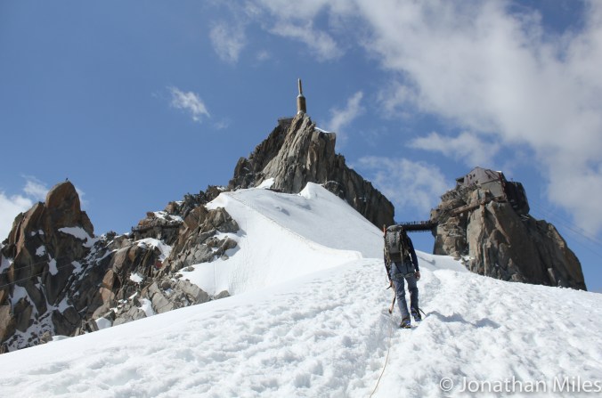
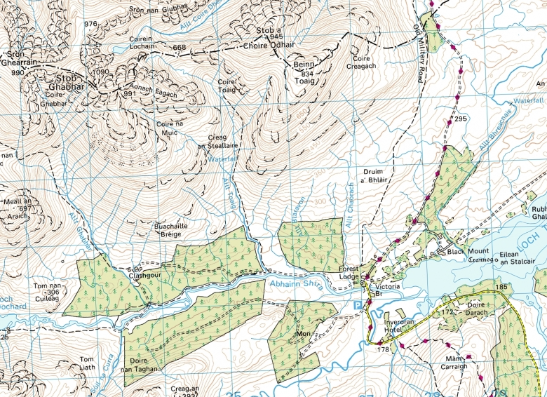
Taxus (III), Beinn an Dothaidh

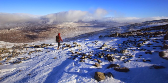
Taxus had been on  my to-do list ever since I first became excited about winter climbing  and spent far too much time with my nose buried in guidebooks picking out must do routes. The climb itself is a classic 3* on the Munro of Beinn an Dothaidh, one of the Bridge of Orchy hills, meaning its easy to get to and more importantly escape to the pub from when either you triumph after a good day, or to commiserate when the weather craps out and you need a warm fire and some single malt to set the world to rights.

Grade III is where I feel comfortable winter climbing, I know its not going to be too hard and scary, never steep for too long and generally a route where I can enjoy myself without any brown trouser moments. At grades IV and V I start to get jittery and look to pass the leading on to someone with bigger balls!

dscf7090

Dom and I had selected it as the first route of a road trip round Scotland a couple of winters back, just offering enough of a challenge to keep Dom who is a much better climber than me interested. As a team all our routes need to walk a fine tightrope between, not so easy that Dom gets bored, but not so hard that I get scared!

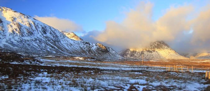
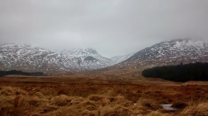
As we have a camper van for this trip we were able to sleep in the car park by the start of the walk in having made the long drive up from Yorkshire overnight. Despite this boon we overslept and were not first, …or even fifth on the route! It was weekend and under clear cold skies and good snow cover everyone was making hay in the conditions and of course heading to the easy classics.

Dom has no body fat and hardly east anything which means unless he is moving he generates no body heat, I don’t know anyone who gets cold so quickly. Thus, rather than wait for the parties ahead of us we headed up a another route called Haar which was supposed to be (III) but was thin and turned out to be the hardest thing we climbed all week even if the difficulties were only a few meters long.

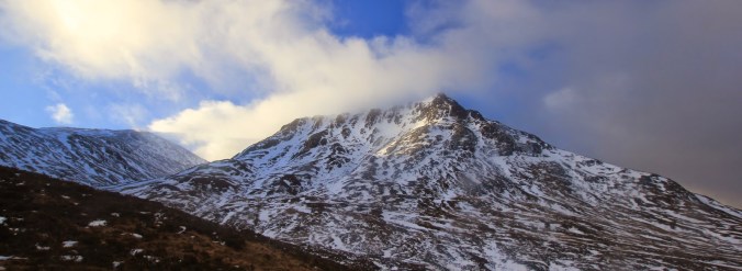
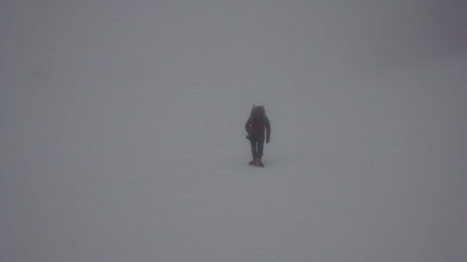
With that route in the bag we dropped down West Gully a broad grade one that leads to the summit plateau and found the waiting list for Taxus had dropped to one team. So we stood around stood around whilst Dom got cold (thats what happens when you get skinny enough to climb 7c) and I stuffed my face with food.

 dscf7084


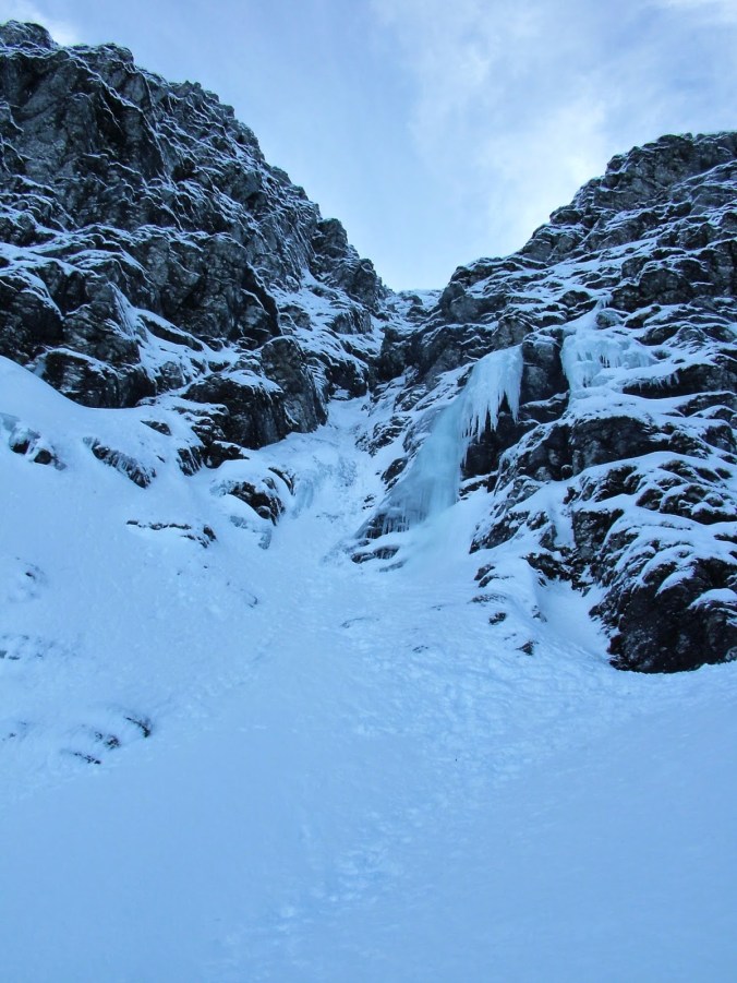
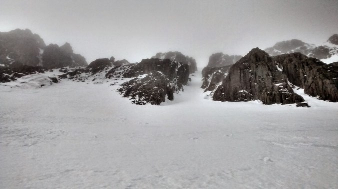
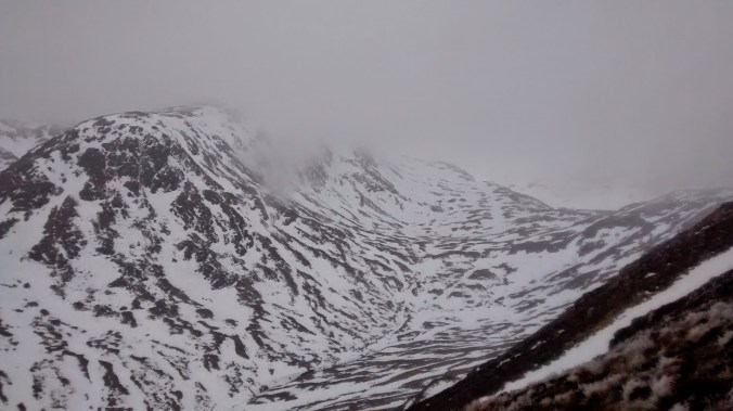
Eventually we managed to get started, the steep gully was well covered with snow but the teams above us had removed most of it from the climbing line leaving the route well tracked. I led the first pitch pretty easily romping up on good neve and thoroughly enjoying myself as the picks of the axes buried them selves deep in the gully with a satisfying thwack!

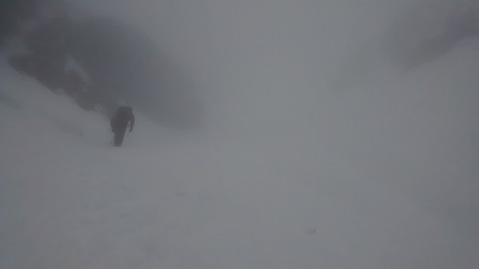
Unfortunately although we had given the team ahead a good start I was very shortly right on top of them as they were both still at the first belay. As there were anchored on the left of the gully I decided not to get in their way and headed to the right in the hope of finding an alternate stance and. I would be stretching the truth to call what I found a belay, more appropriate words to describe it would be marginal, and psychological. Dom powered his way up and instructed him not to, under any circumstances to weight on the belay… or even look at it.

From the belay the next five meters or so were steeper and looked to be the crux, the other team had moved about 10 m in the time it had taken Dom to climb the entire first pitch, so things did not look good especially for the man with no body heat if we could not get passed them. Fortunately the gully was wide enough to allow Dom to seek past on the left having asked if it was ok.

We thanked them but i’m not sure what they made of the fact that once Dom was over the ice step he in his words he Ueli Steck’d it past the leader, practically running up something they were taking significant time climbing. The step proved to be the last difficulty on the route an easy snow gully leading to the summit.

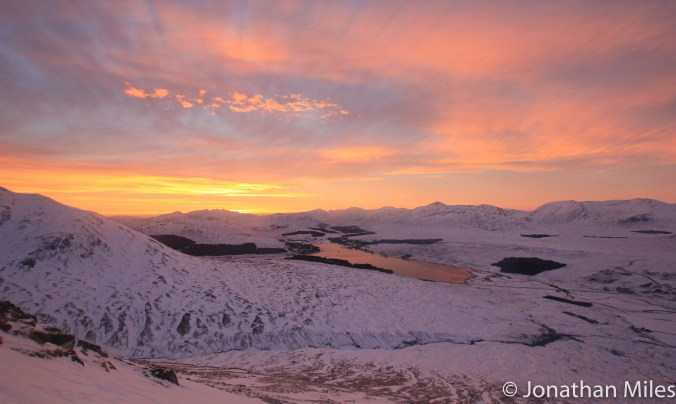
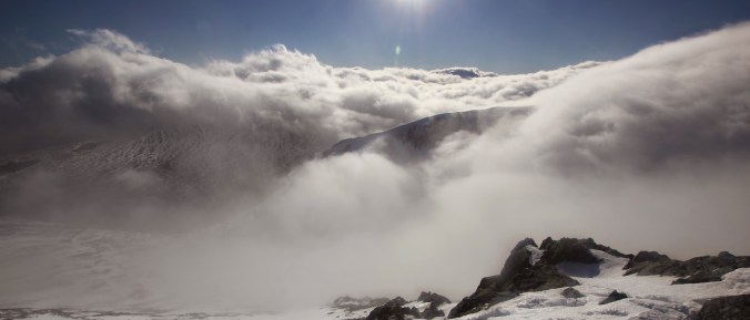
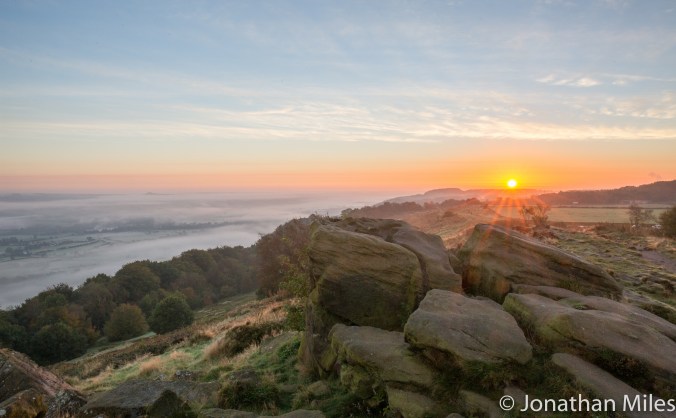
Still feeling pretty fresh we then traversed round to Beinn Achaladair, which took longer than expected and were rewarded with a fantastic sunset over Loch Tulla as the sinking sun panted the skies in a riot of orange and liquid gold.

Glencoe (1 of 2)

Advertisement

Mountain Biking in the Galloway Forest

The smell of the pine forest in the damp air is all pervading, fresh and clear to the nose; trees in long regimented ranks march out into the distance close packed like phalanx upon phalanx of soldiers, a wall impenetrable and dark. Trunks arrow straight stand sentinel stand guard above the track, and from above comes the gentle rustle of pine needles in the wind. Ahead the fire road, a river of grey at the bottom of a canyon of green and brown winds it’s way off into the distance before bending round and out of site.

The road vanishes behind, devoured beneath the wheels of the bike which flows gracefully over the packed gravel as pedals beat out and easy rhythmic cadence. Above the trees and higher still the hills of Galloway tower above the forest.

img_6850-2

I’d had my eye on biking in Galloway for a while, particularly the Glentrool Tour one of the standout routes in Phil McKane’s Scotland Mountain Biking. A monster on the legs, and clocking in at about 90 km it ranges between Loch Doon in the north of the forest and Minnigaff in the south. Not quite fancying that distance in one bite and not having the time to split it over two days I decide to ride the northern section and chop the loop just below half hight by using a good track between Loch Trool and Loch Dee bringing the distance down to about 70km.

Using the Glentrool car park as a starting point the route follows the road up the valley until the tarmac fades and deteriorates into a good forest road which slowly climbs up the hillside. Arriving at a coll the track drops away and the view opens out to reveal Loch Dee shining in the mist and the great post war forestry plantations of pine in the valley of the Silver Flowe.

Later the route goes passed the now abandoned MBA both of Backhill of Bush, it’s occupied with smoke coming from the chimney and a van parked up outside, symptomatic of the problems with vandals and antisocial behaviour which sadly forced the MBA to stop looking after this bothy.

img_6912_2-2

There are a lot of forest opperations going on at the moment with large areas being harvested and replanted and new roads being constructed to facilitate this.  A few miles past the bothy a new track  not shown on the map leads off into the trees freshly buldosed into the forest. It heads in the direction I want and looks heavily used compared to my chose route but not knowing if it goes all the way through to Loch Doon I stick with the guidebook, although considering the upcoming difficulties it may have been worth a try! 

I follow the guidebook route which is described simply as a short “off-peiste” section through the fire brakes. It soon becomes clear few if any riders have passed this way recently, the brakes are a mass of thick tussocky grass and soft sucking bog, challenging even to walk through with a bike and certainly unrideable. It soon gets worse with a small river crossing followed by the piste de resistance, the fire brake is completely blocked by fallen trees forcing me to push through the thickly packed limbs and mass of dead lower branches. 

I hope the new road does go all the way through the forest, this off road section is just nasty; it’s completely out of character for the ride which apart from this short section is a glorious (if long) route for mountain bikers of almost any ability. Frustratingly taking almost an hour to cover about 1.5km whilst carrying a bike pushed my sense of humour to the limit and could completely put off occasional bikers or beginners from moving from trail centres to somewhere a little wilder.

Back on solid trail and a few kilometres later I emerge from the forest on the shore of Loch Doon, which under overcast skies appears forbidding and barren. Lunch is taken inside the stout walls of  the ruined Loch Doon Castle. As time passed, and I began to think about the castle and its surroundings the more nothing made any sense, something about the castle was wrong; it sits on the side of a hill easily overlooked by surrounding land and with its main door opening straight out into a steep slope. 

Loch Doon Castle - geograph.org.uk - 95470

Brian Joyce [CC-BY-SA-2.0 (www.creativecommons.org/licenses/by-sa/2.0)], via Wikimedia Commons

Such eccentric positioning, and orientation suggests the builders paid little or no attention to the finer points of siege warfare, which would therefore not have allowed the castle to last very long in the turbulent history of the Borders. Later it transpired all was not what it had seemed, this castle has migrated! The strange positioning is not the result of a particularly mad local laird but the conscientious decision of the Board of Works in the 1930’s who upon raising the water level of the Loch took the castle from it’s old soon submerged island home and reassembled it in it’s current location.

From Loch Doon the ride follows the Forest Drive, closed to traffic at this time of year up through more open woodland of pine, fern, and lochan until it emerges from the forest and back onto tarmac and public roads practically at the high point of the ride. From here it’s a last joyous 20km downhill along quite country roads the gradient taking on the work leaving me with little to do other than enjoy the  great views across to the Merrick. With almost six hours on the bike my legs are beginning to let me know they are in need of a rest and this is the perfect way to finish, all I need now is to fire up the stove back at the car and enjoy a well earned cup of tea. 


Tarn Hows Microadventure

I first saw a picture of Tarn Hows in a book on landscape photography and was instantly captivated by the beauty of the view. The mirror still waters of the tarn surrounded by trees in the full riot of autumn colour, complemented by a group of slender pines on a spit of land which jutting out into the lake to lead the eye towards the mountains in the distance.

The tarn nestles in the low hills between Windermere and Coniston Water, an area I had always bypassed in search of walks and climbs on the higher fells to the north. This weekend I visited with the idea of camping and capturing the location at sunset and sunrise.

tarn-hows-1-of-1

The Classic View

I took some shots as the sun sank slowly towards the horizon as shadows crept slowly up the bowel of the tarn and onto the hills beyond. I pitched the flysheet to face the view even though the ground was scarcely wide or level enough to do so. I’m currently using my one man tent flysheet as a tarp until I can splash out on a Trailstar.

With tea brewed I sat down to welcome dusk. As the light faded hundreds of birds swooped cartwheeled and darted just over my head, calling to each other as they zipped through the air with an audible whoosh.

tarn-hows-2-of-2

Reflections, shame about the leden sky

There are the best of my images, the trees need a little more time to retreat to their more stark winter shapes, sacrificing their leaves to give them the energy to make it through winter.

tarn-hows-1-of-2

I liked the stark reflection of the dead trees

Ok this last one is not great…

tent-1-of-1

Nice campsite!

New Name for the Site

You may have noticed the website URL has changed from Jonathanmilesphotography.com to Bootsboatsandbike.com. I had thought this would be a bit of a nightmare but it was actually really simple. The reason for the change is because I need the former to name for a new photo sales site I’m hoping to set up in the next few months. This blog will continue as as normal.

I chose the new name because all my stories and photos do involve an adventure with boots, in boats, or on bikes!

Apls (1 of 5)

A Winter Adventure – Creise, Glencoe

Originally published in April 2015 on my old blog.

Having spent the night parked at the Glencoe ski centre whilst the wind whistled and shrieked around the van, things had not sounded very promising for a good day on the hills come morning. With dawn however, the winds had fallen slightly although they were still energetically gusting and rushing between the hills causing clouds to scud and dance around the peaks as we shouldered our packs and began the walk in to Sron na Creise.

A line of telegraph poles marked our route across the floor of the valley as they marched through a landcape of tussocky bog which because of the cold night was thankfully well frozen. The wind was bitterly cold but the early morning sunlight was beginning to cast a warm glowing light on the snow shining below a beautiful blue sky.

img_2985

The Buachaille dances with the morning clouds

Rounding the spur of Creag Dhubh,  Sron na Creise comes into view a series of gully lines clearly visible cutting through the rock headwall above its north facing choire. We had wanted to climb the classic Inglis Clarke Ridge, a classic very easy mixed line; but as we approached, it looked more and more out of condition, black buttresses staring back at us  unwelcoming and obviously ice free. The Weep would have been a good fall back option but a) we did not know about it and b) looking back at my photos the fun bits looked buried!

img_2992

Sron na Creise

Central Gully which is only grade 1 was easy to find, arrow straight it leads up through the cliffs that guarded the choire rim, and was full of good neve making the climbing easy and enjoyable. Unfortunately we could not take advantage of the undoubted magnificence of the situation and views, as by now cloud had entombed the mountain and by the time we reached the summit ridge a bitter wind was blowing.

img_20150209_110135993_hdr

Not easy to get off route…

From the top of the climbing it’s about a kilometre along a broad ridge to the summit of Criese proper. Following a compass baring we had to make sure we did not stray onto any cornices in the poor visibility, our path illuminated by a watery, hazy sun which barely managed to break through the cloud with any definition.

Having basked in the magnificent summit view we looked to find the route across to a neighbouring munro Meall a Bhuiridh which joins Creise by a very narrow ridge and col about fifty meters below the summit plateau. Visibility was poor and after we had paced out the distance all we could see was the eastern slopes of the mountain falling away steeply into Mam Coire Easain with no obvious lines of weakness to hint where we should descend.

We hunted round in the clag that surrounded us and eventually spotted a small cairn which convinced us we were in the right place, even if the angle of the slope suggested otherwise! Having cautiously descended about 30m vertically, the gradient relented and the ridge line emerged out of the mist as the clouds began to clear to revel the summit cone of Meall a Bhuiridh ahead.

img_3005

Whales in a stormy sea

Having crossed the windswept col we pulled steeply onto our second Munro of the day and with it the weather changed again. As we reached the summit we broke through just high enough to be clear of the cloud inversion. It was one of those fantastic moments that the hills sometime offer you; like standing on a lonely rock at the edge of the sea, the clouds rolling and boiling around us as the ridges of the surrounding hills broke in and out of view like giant whales surfacing in a stormy sea.

Meall a Bhuiridh is also home to the Glenco ski centre, the lift of which reach almost to the summit. As we descended along the edge of the piste the clouds slowly cleared in front of us revealing the endless stage of Rannoch Moor locked tight in winters grip. A great day.

img_3013

Dom descends towards the ski centre with Rannoch Moor in the distance

I captured some of the day on video using a mix of go pro head cam and my SLR.

The Black Mount

Updated from my old blog just to get everyone in the mood for winter…

Stob Ghabhar and Stob a Choire Odhair are two Munros that form part of the Black Mount west of Rannoach Moor and overlooking Loch Tulla. Climbing Stob Ghabar in winter is made a little bit more interesting two easy snow couloirs imaginatively (in what must have been a burst of creativity) given the titles “upper” and “lower” with give access to the summit from the north.

The Lower Couloir leaves from just above a small lochain perched high up at the head of the Allt Cchoire Dhearbhadh itself a long slog across the high plateau west of the West Highland Way as it crosses Rannoach Moor.

Looking for some climbing on a dull overcast day Dom and I decided to approach from the south parking near Inveroran and walking up the old stalkers track that runs up into to Corie Toaig and the col at 668m between the two Munros. From here it looked like a short traverse round to the lochain and the climbing.

img_20150211_090929457

Overcast sky above Loch Tulla

IMG_7177

Loch Tulla in slightly better Weather

img_20150211_151804278

Corie Toaig


IMG_7176

I think this is the same peak in slightly better weather?


A good track leads most of the way to the col, crossing the snow line at about 500m we are soon enveloped in thick fog which obliterates the horizon and leaves us struggling for reference points as snow and sky blur in to one and classic Scottish white out conditions. The disorientation especially on relatively open ground makes route finding difficult and both Dom and I have to work hard to make sure we hit the col at the right point as I display an alarming tendency to let the terrain pull me too far to the east.

From the col there is no chance of catching sight of the lochain and we are faced with a mass of white cloud into which we descend on a baring taken off the map; pacing out the distance we take great care, conscious of the fact that the lochain is probably frozen with a covering of snow – not a good place to blunder out on to!  Finally in the matt light which surrounds us the eyes catch sight of a hint of blue snow to our right giving away the position of the water, barley noticeable in the fog.

img_20150211_113311148

Where are we?


img_20150211_114823709

Really, where are we???


However finding the lochain was only the start of the difficulties, with viability so poor there is no sign of the couloir or even any real rock bands above us, leaving us with little indication of where to go. The 1:25:000 OS map indicates a spur of rock running down to the edge of the water which forms the right hand edge of the run out fan leading up into the funnel of the Lower Couloir. Contouring a safe distance from the edge of the water we traverse round until this band of rock emerges from the mist then turn left and begin to climb steeply. The couloir is wide and its only after a couple of hundred meters that it narrows to the extent we can see both walls giving us the confidence we are on the right track. The terrain is steep of grade 1 but we have finally come across a line of foot prints for us to follow making the work easier and helping convince us we are on the right track.

The gully finishes on a steep upper snow field, continuing straight up would eventually lead to the summit but to reach the Upper Couloir we must traverse left over steep terrain which were it not for the zero visibility would feel very exposed. The architecture of the mountain is very difficult to piece together in this weather but our route is clear from this photo on UKC showing the narrow gully cutting a crescent shape through the summit buttress. 

The gully itself is excellent, narrow and well packed with good ice, a grade harder than the Lower Couloir with a step of grade II where I wished the rope was not snug and secure in my rucksack as I climbed it. I captured the short brown trouser moment for posterity below.


The gully finished pretty much on the summit which was being lashed by a bitterly cold wind and not the place to linger especially without any view to distract the attention and the camera. We quickly dropped down the ridgeline to the col grabbed a bite to eat and then traversed on to Stob a Choire Odhair which felt hard on the legs which had already put themselves through a significant amount of accent. On the top I was forced to deploy the emergency Harribo for a sugar filled decent back down to the van.

img_20150211_142840295

Stob Ghabhar from Stob a Choire Odhair

black-mount-1-of-1

The Black Mount in slightly better weather

Sunrise Inversion

On Monday morning I visited the Chevin above Otley based on a good forecast for a sunrise and cloud inversion, I was not disappointed! Rather than the Warfe Valley being full of cloud it was patchy with fields and trees poking through the dendrites of cloud. Almscliffe Crag poked through the cloud in the middle distance and the sky took on the distinctive colours of a sunrise approaching winter.

chevin-3-of-4

The sun emerges from behind the ridge

chevin-2-of-4

Almscliffe Crag in amongst the clouds

chevin-4-of-4

As the sun rose above the horizon I managed to capture this sunburst