Not Quite Winter on Carn Liath and Beinn Udlamain

Those few days between Christmas and New Year are often a holding pattern between the consumption of too much food and the consumption of too much alcohol. As the days are mandatory holidays for me, and I had just about worked through the myriad of snacks that accompany the festive celebrations it seamed like a good idea to head somewhere for a few days in the hills to address the calories in the bank so to speak.

I’m particularly inspired by climbing and walking in Scotland in winter, drawn by the thought of peaks and ridges capped with crisp snow set against a blue sky. As someone who lives 400 miles away from the Highlands I tend to view weather forecasts around my windows of opportunity in my work calendar through slightly Quixotic glasses and possibly myopic fashion, always hoping conditions will be slightly better than advised!

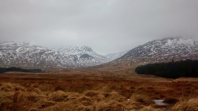
By Boxing Day however any optimism I may have held about a few days on the west coast had been battered into submission by storms Barbara and Conor and my hope of a to north looked to be fading. Looking for a straw to grab a hold of a few pictures glimpsed on Twitter of snow settling around Loch Morlich convinced me that the Cairngorms could allow me to snatch a few days wintering before heading back to work.

blog4

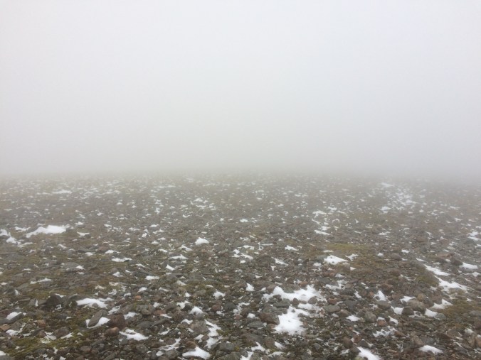
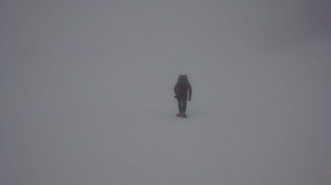
Looking for the summit

Four hundred miles later and it was clear that the skis, crampons, and axes were going to stay in the car as temperatures rose rapidly to high single digits, bringing wind and cloud to dominate the forecasts. Rather than use my time to slog up a gully full of soft rapidly melting snow I decided to use my time to visit two  Munros I’ve missed during previous trips that would otherwise get overlooked as I slowly work through the remaining 200 on my to do list.

Beinn Udlamain (1011m) is one of four rounded hills that lie just west of the A9 at the Drumochter summit, all four are a reasonably reliable ski tour with snow often down to road level and I had been able to pick three of them off like that during earlier trips. Beinn Udlamain lies farthest from the road and had therefore been left till last. In good weather experienced ski tourers (which I’m not) could easily link together at least two and possibly all the summits without too much difficulty.

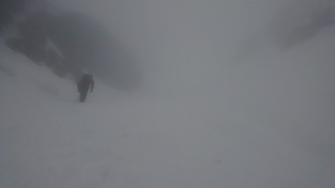
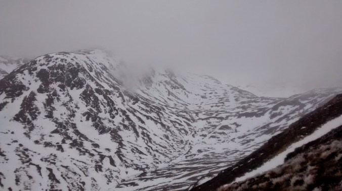
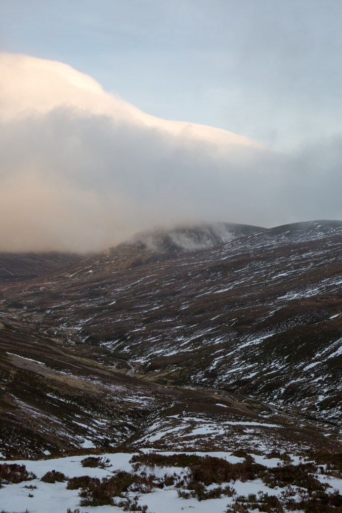
With a light pack, not requiring much usual winter kit, I followed the landrover track from the A9 up Coire Dhomhain, the head of which was lost in a opaque  ceiling of grey cloud. Reaching an obvious stream coming down from the coll between Beinn Udlamain and  A’ Mharconaich I turned up a stiff climb over grass and hether but very little snow.  Higher up there was a covering of the white stuff, which in the cloud brought a virtual whiteout and disconcerting slog up into nothing.

Finally the seeming interminable white slope gave way to a rounded broad ridge clear of snow which I could follow via a couple of doglegs (and well spaced old fence posts) to the summit after just over a kilometre.
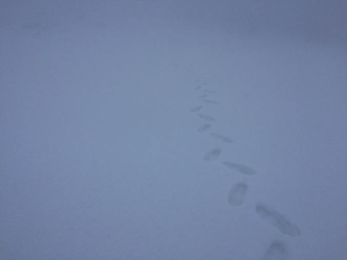
15747412_10100427264243069_3876748215602161377_n

One of those days!

blog2

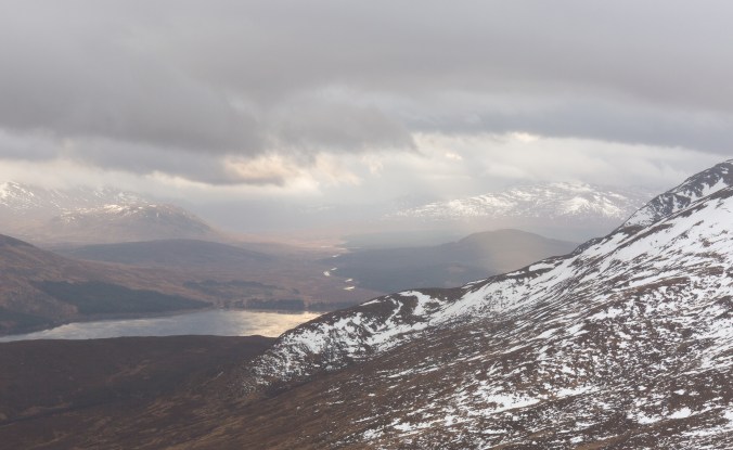
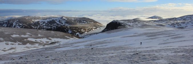
Cloud banks above the Sow of Atholl

With the summit shrouded in grey mists Beinn Udlamain lived up to one translation of its name, the “gloomy mountain”; although to be fair to it, in climbing its three neighbours Geal-chàrn, Sgairneach Mhòr and A’ Mharconaich I’ve never been able to see more than about 100m on any of the summits missing what must be good views across to Ben Alder and Loch Erict.

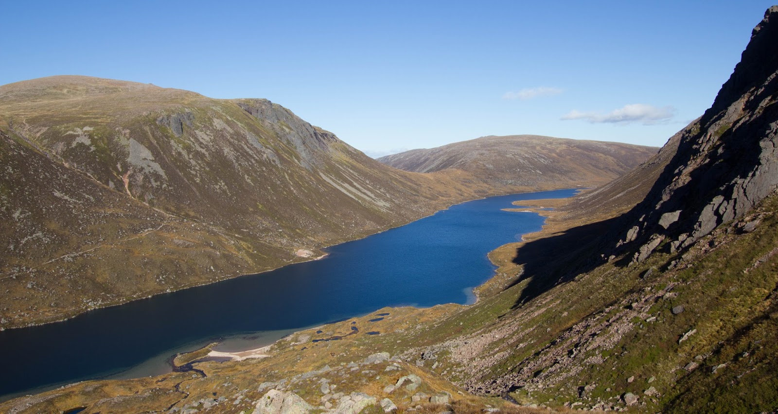
The second peak I picked off was Carn Liath which lies above Loch Laggan and is often climbed with (and probably overshadowed by) Creag Meagaidh a fantastic mountain with, in my opinion the finest winter coire in Scotland in Coire Ardair.

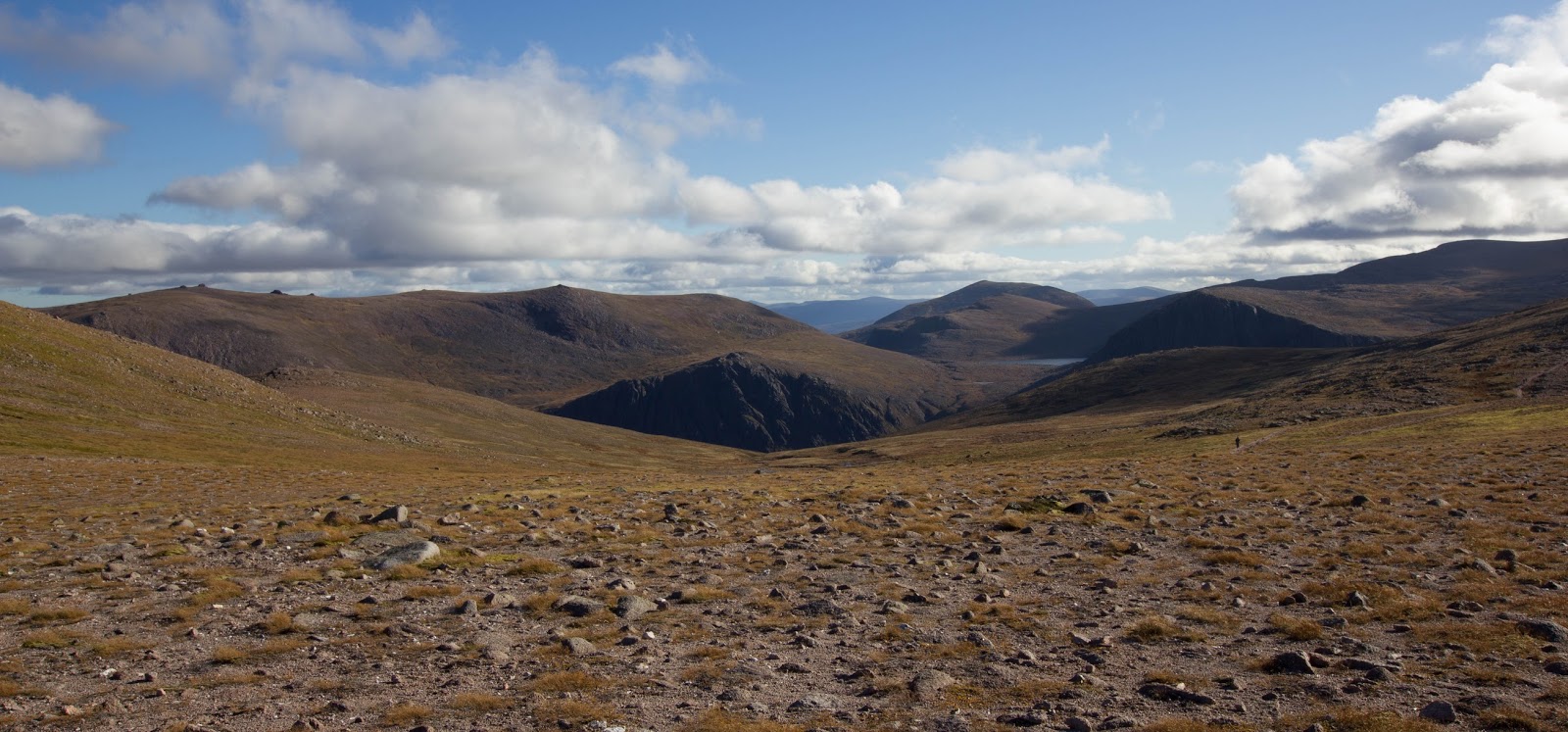
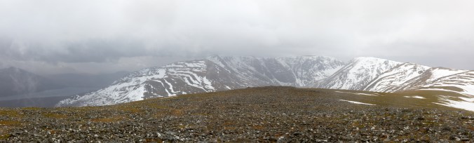
The route (faint path) left the excellent path to the coire just before it enters the woods and climbs steeply up onto the shoulder of Na Cnapanan. I say path in the loosest possible terms as for its lower half it was little more than a stream weaving its way through holders and trees! Higher up things improved and from the shoulder the gradient relents giving an easy climb up to the main summit all the while offering a fantastic view across to Coire Ardair across whose headwall you can trace the classic steep climbing gullies of the Post Face .

Today these looked a little forlorn, thin and surrounded by black rock with only Easy and Raeburn’s Gully looking climbable and even then probably a slog through soft snow. Even looking forlorn though I still find the sight inspiring there are some brilliant days to be had here.
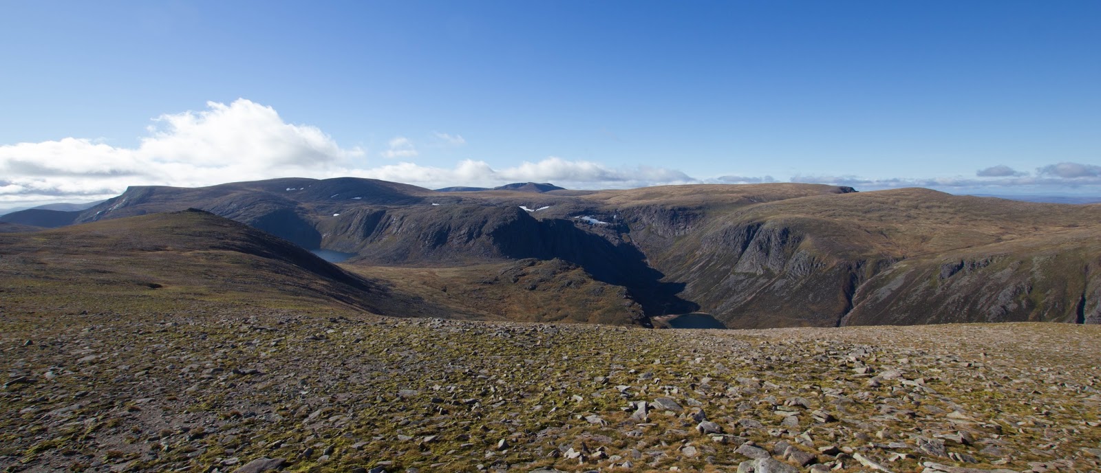
blog3

Coire Ardair

Creag Meagaidh has pride of place as one of my most frustrating mountains; possibly like nowhere else in Scotland it balances on a knife-edge between not enough snow and lethally too much snow. The vast plateau behind the coire collects huge volumes of the stuff which when moved about by easterly winds makes it an avalanche black spot and home to some colossal cornices.

A few year back in good conditions I remember seeing some massive old avalanche debris whilst climbing up through the notch in the back of the coire known as the Window. Its not somewhere I want to venture on a marginal forecast from SAIS.

Hopefully this will be the first of a few days in Scotland this year, I’m hoping to focus on ski touring with quite a few munros lined up should conditions click.  That said if I can grab a few easy gullies later in the season that would be a bonus too!

blog3-2

Advertisement

The Black Mount

Updated from my old blog just to get everyone in the mood for winter…

Stob Ghabhar and Stob a Choire Odhair are two Munros that form part of the Black Mount west of Rannoach Moor and overlooking Loch Tulla. Climbing Stob Ghabar in winter is made a little bit more interesting two easy snow couloirs imaginatively (in what must have been a burst of creativity) given the titles “upper” and “lower” with give access to the summit from the north.

The Lower Couloir leaves from just above a small lochain perched high up at the head of the Allt Cchoire Dhearbhadh itself a long slog across the high plateau west of the West Highland Way as it crosses Rannoach Moor.

Looking for some climbing on a dull overcast day Dom and I decided to approach from the south parking near Inveroran and walking up the old stalkers track that runs up into to Corie Toaig and the col at 668m between the two Munros. From here it looked like a short traverse round to the lochain and the climbing.

img_20150211_090929457

Overcast sky above Loch Tulla

IMG_7177

Loch Tulla in slightly better Weather

img_20150211_151804278

Corie Toaig


IMG_7176

I think this is the same peak in slightly better weather?


A good track leads most of the way to the col, crossing the snow line at about 500m we are soon enveloped in thick fog which obliterates the horizon and leaves us struggling for reference points as snow and sky blur in to one and classic Scottish white out conditions. The disorientation especially on relatively open ground makes route finding difficult and both Dom and I have to work hard to make sure we hit the col at the right point as I display an alarming tendency to let the terrain pull me too far to the east.

From the col there is no chance of catching sight of the lochain and we are faced with a mass of white cloud into which we descend on a baring taken off the map; pacing out the distance we take great care, conscious of the fact that the lochain is probably frozen with a covering of snow – not a good place to blunder out on to!  Finally in the matt light which surrounds us the eyes catch sight of a hint of blue snow to our right giving away the position of the water, barley noticeable in the fog.

img_20150211_113311148

Where are we?


img_20150211_114823709

Really, where are we???


However finding the lochain was only the start of the difficulties, with viability so poor there is no sign of the couloir or even any real rock bands above us, leaving us with little indication of where to go. The 1:25:000 OS map indicates a spur of rock running down to the edge of the water which forms the right hand edge of the run out fan leading up into the funnel of the Lower Couloir. Contouring a safe distance from the edge of the water we traverse round until this band of rock emerges from the mist then turn left and begin to climb steeply. The couloir is wide and its only after a couple of hundred meters that it narrows to the extent we can see both walls giving us the confidence we are on the right track. The terrain is steep of grade 1 but we have finally come across a line of foot prints for us to follow making the work easier and helping convince us we are on the right track.

The gully finishes on a steep upper snow field, continuing straight up would eventually lead to the summit but to reach the Upper Couloir we must traverse left over steep terrain which were it not for the zero visibility would feel very exposed. The architecture of the mountain is very difficult to piece together in this weather but our route is clear from this photo on UKC showing the narrow gully cutting a crescent shape through the summit buttress. 

The gully itself is excellent, narrow and well packed with good ice, a grade harder than the Lower Couloir with a step of grade II where I wished the rope was not snug and secure in my rucksack as I climbed it. I captured the short brown trouser moment for posterity below.


The gully finished pretty much on the summit which was being lashed by a bitterly cold wind and not the place to linger especially without any view to distract the attention and the camera. We quickly dropped down the ridgeline to the col grabbed a bite to eat and then traversed on to Stob a Choire Odhair which felt hard on the legs which had already put themselves through a significant amount of accent. On the top I was forced to deploy the emergency Harribo for a sugar filled decent back down to the van.

img_20150211_142840295

Stob Ghabhar from Stob a Choire Odhair

black-mount-1-of-1

The Black Mount in slightly better weather

Beinn Mheadhoin and Loch Avon

First published on my Blogspot site 15th October 2015

The first few days of my trip north had been characterised by low cloud and drizzle, the weather suggested little prospect of a good day on the hills with the peaks of Cairngorms lost in a blanket of grey cloud smothering out the sun. Having brought my bike with me I had passed the time with a good ride through the woods of Rothiemurchus and and run between Loch Ericht and Loch Laggan via the remote Loch Pattack the bike making short work of the landcover tracks now carved deep into the hills.

Today was different a glimmer of hope to my drenched expectations as I was fast running out of dry cycling kit. The forecast was for a high pressure system to settle over the northern Cairngorms giving blue skies and an excellent opportunity for a long walk into one of the more remote Munros on my still very long to do list; Beinn Mheadhoin situated south of Loch Avon in the heart of the Cairngorms. 

cropped-cropped-img_97431.jpgA winter view of Beinn Mheadhoin (left) and Carn Etchachan (centre) taken from the top of Coire nan Lochan

A hill I had often seen from afar, its distinctive granite tors is easily visible from the top of the Northern Corries after a days climbing but from any further approach it is well guarded from casual suitors by the deep trough containing Loch Avon which to my knowledge must have a good claim as being the most remote large body of water in the UK.

The air was cold and crisp as I left the ski centre carpark but as the sun continued to rise its rays soon provided a warming glow as a worked my way through the clutter of ski detritus that is Coire Cas in summer as various bits of heavy plant dig and scrape their way about the hill in preparation for the coming season. Snow cannons sit forlornly beside a maze of picket fences and lift cables look incongruous agains the heather.

Looking down the gentle slopes of Coire Raibeirt towards Beinn Mheadhoin its tors clearly visible against the skyline.

Having joined the path up to imaginatively named point 1141 which is perched on the shoulder of Cairn Gorm I follow a faint path across the plateau which drops down the gentle slopes of Coire Raibeirt picking up a small stream of tumbling water as it goes. Beinn Mheadhoin dominates the view whilst Loch Avon itself remains hidden in a deep trough ahead only becoming visible at the last minute as the path drops very steeply downwards out of the hanging corie towards the deep blue water. The decent is very steep and strenuous efforts have been made to build stairs down for much of the route saving what would be a pretty horrific scramble over loose rock although the path does eventually end up in the stream bed, no doubt the decent is a nightmare if coated in verglas in winter!

Towards the bottom I cross the stream and pick up another rough path which leads after much bolder hopping to the head on Loch Avon. The remoteness is palpable, a wild place with steep hills and crags on three sides with just the narrow opening to the north west containing the loch itself. The Feith Buidhe cascades down from high on the slopes of Ben Macdui and is crossed on stepping stones where it enters the Loch.

I make a short detour to visit the famous howff of the Shelter Stone one of hundreds of huge boulders that erosion has prized off the encircling crags which now lies across its neighbours creating a sheltered bivvy cave famous in Cairngorm mountaineering history as the base for many climbers exploring routes on the faces above. The shelter is one of many dotted throughout the bolder field no doubt welcome places to rest for those who brave these parts in the depths of winter, if they can find them in amongst the deep drifts of snow. 

Loch Avon with the slope of Cairn Gorm behind.

 Loch Etchachan

From the head of the loch a path climbs steeply to the col between Carn Etchachan and Beinn Mheadhoin, nestled just beyond this is Loch Etchachan the highest large body of water in the UK at over 900m above sea level; it looks a lovely place to camp in good weather surrounded by such awesome scenery. Just before the outflow of the loch I turn up the hillside to the northwest and climb steeply onto the summit plateau of Beinn Mheadhoin. The landscape is flat and stony with very little vegetation, a testament to the difficult year round conditions plant life faces clinging to life in the poor soil. 

The expanse of the summit is dominated by a series of high granite tors their sides wrinkled like old leather and the largest and highest of which proves to be the summit.  Having scrambled onto the top to me they almost almost justify inclusion alongside the Inn Pin as a Munro needing some climbing skills (but not ropes), certainly there are a couple of moves which would not be out of place on a v. diff

The three summit tors, the highest point being the central tor.

The view from the top is quite spectacular, for 360 degrees hills stretch out around you with no sign of roads, houses or the clutter of modern life, its a place to stop and savour just being in a landscape absorbing it in to enrich your soul before heading for home. I spend about half an hour playing about with my camera taking bracketed exposures to try and compensate for the contrast in light conditions which makes exposing both the brilliant blue sky and green brown earth a really chained even with a couple of graduated filters. Finally having had my fill of the view leaving the summit I retrace my steps back down to Loch Avon as the shadows of the day begin to lengthen.

Naturally having decended steeply this morning its a tough climb back the way I came onto the Cairngorm plateau but the babble of water keeps you company and refreshed. Loch Avon is certainly somewhere I would like to return to, perhaps trying to approach from the west and the Fords of Avon by bike or to explore with a packraft, but those are adventures for another day.

The view from just shy of the summit back to Loch Etchachan and Loch Avon, the count back to Cairn Gorm is the steep gully about a third of the way in from the left.