My only previous trip to Skye had been the weekend of the royal wedding in an attempt to get as far away from the sycophancy as possible. We were rewarded for our unpatriotic behaviour by brilliant blue skies, low wind, and bright sun during a reeky of the Cuillin Ridge; the weather it transpired was obviously republican too.
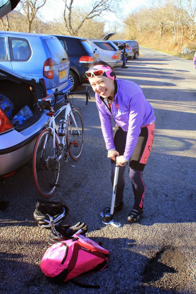
After last years coast to cost I had suggested to my friend Lisa that we head to Skye for a cycle tour through one of the most spectacular landscapes in Europe. As the easter weekend approached the weather in the highlands resolutely refused, much to our general consternation, to get much above freezing point. Fortunately though, although cold temperatures were forecast there was also hints that wind the cyclists worst enemy would be absent and we would cycle under clear skies, this sealed the deal and the car was turned to point north.
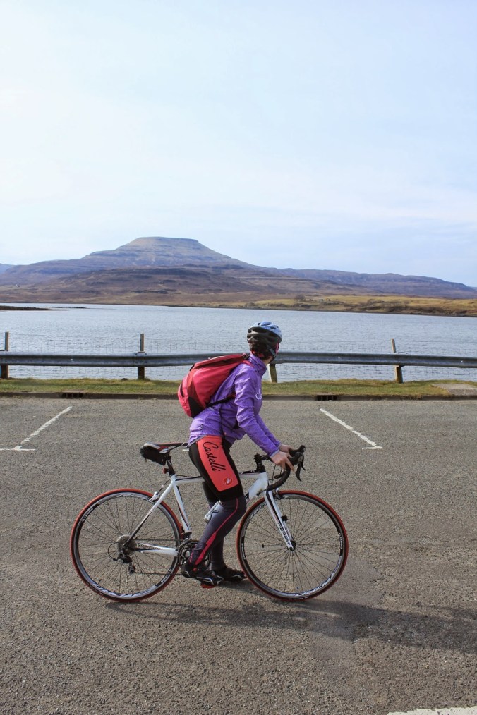
There was a little extra excitement in this trip too; a firm believer in the n+1 rule I had just collected a new bike from the bike shop only the day before. Replacing my ten year old metal Carrera with 7.7kg of the finest carbon fibre in a rather fetching matt black Fuji Grand Fondo currently sitting in the boot of the car just waiting to be let loose on the roads.
So Pretty, the View is Not Bad Too!
Under Pressure
Day 1: Broadford to Dunvegan
After a days driving and an overnight in the Broadford youth hostel we woke to a stunningly clear day with views out to the mainland over Broadford Loch the sun glinting off a calm sea. Dispite the distinct chill, the air was clear and fresh; not wanting to waste any time bags were packed with alacrity, bikes were fettled, and the road was hit.
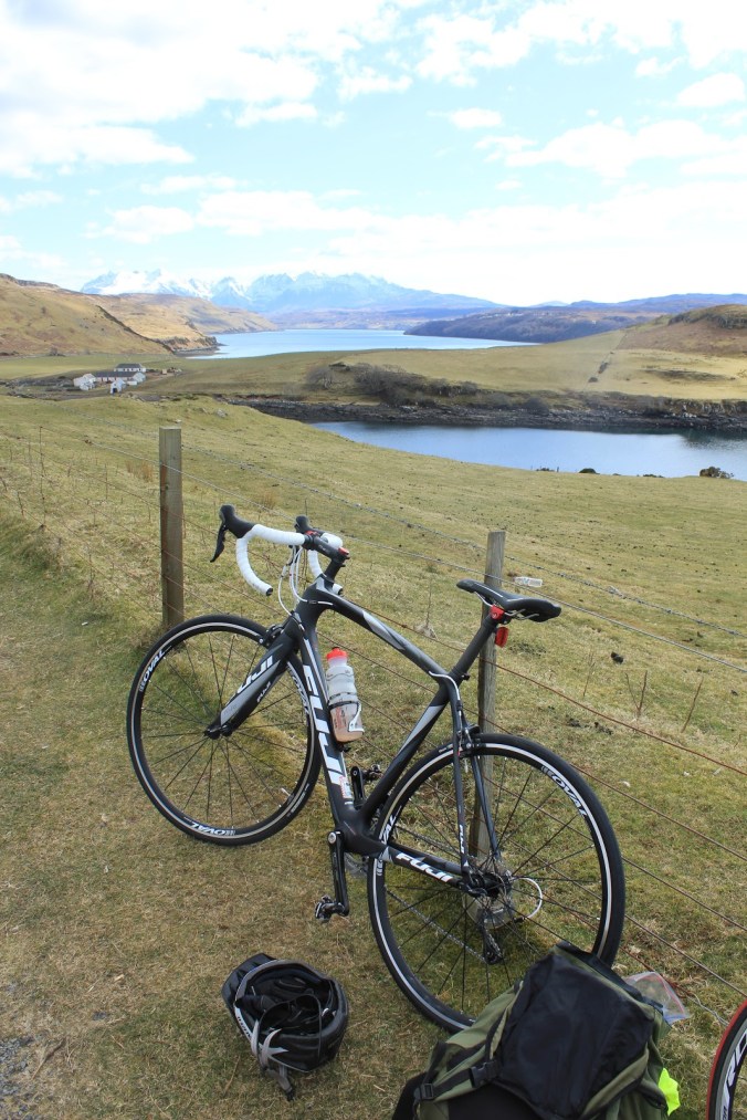
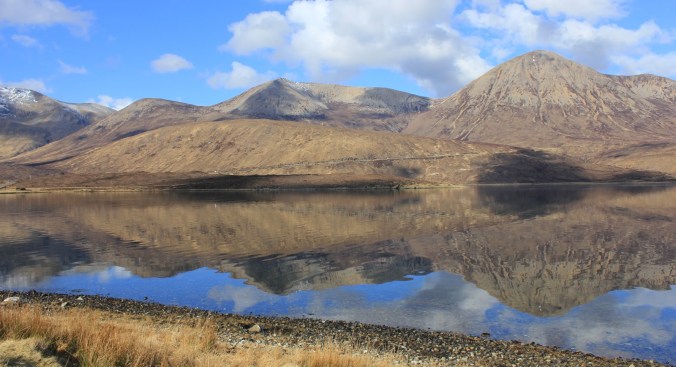
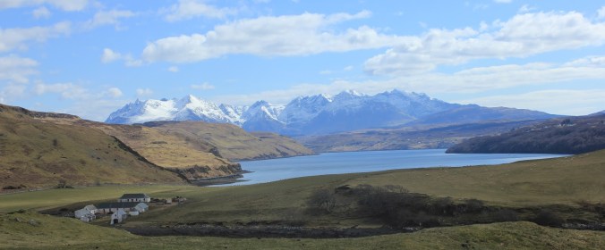
The first stage was to take the main road out of Broadford and head out towards the Sligachan Inn which sitting below the Cuillin Ridge lies perhaps in the most ridiculously scenic location of any accommodation in the UK. About 10km after leaving Bradford the road swings round and follows the shore of Loch Ainort and you get the first great vista of the mountains of Skye with the hills of the Red Cuillin swinging into view and stretching out along the north side of the loch.
With the lack of wind the waters of the loch were almost mirror still reflecting the towering grey red cones of the surrounding hills as perfect mirror images reflected against a blue sky. The harsher more jagged Black Cuillin were visible at the end of the loch dusted with a light covering of late season snow and looking a much more fearsome proposition. Memories of my previous trip to Skye and a first experience on that ridge spring back into my mind, another reason to return here.
The Road Round Loch Ainort
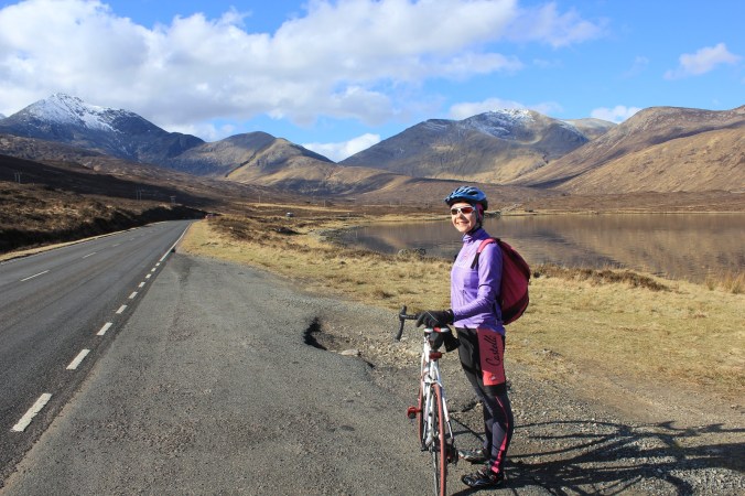
Once round the head of the loch the road climbed for the first real hill of the day, but was never actually that steep and the road surface was excellent allowing us to dispatch the climb with ease. Once over the top we were rewarded with a fast sweeping decent which carves down the hillside through a sea of green and brown heather lining the road as it descends towards Loch Sligachan which glints a deep blue in the distance.
Approaching the head of the loch we cycled along below the great cone of Glamaig which towered above us at a quite ridiculously steep angle as slowly the peaks of the Cuillin ridge crept out from behind its precipitous sides. Arriving at the Inn I quickly checked they had our booking for a few days hence and we warm up with a cup of tea and a fantastic view.
The Red Cuillin Reflected in an Almost Mirror Still Loch Ainort
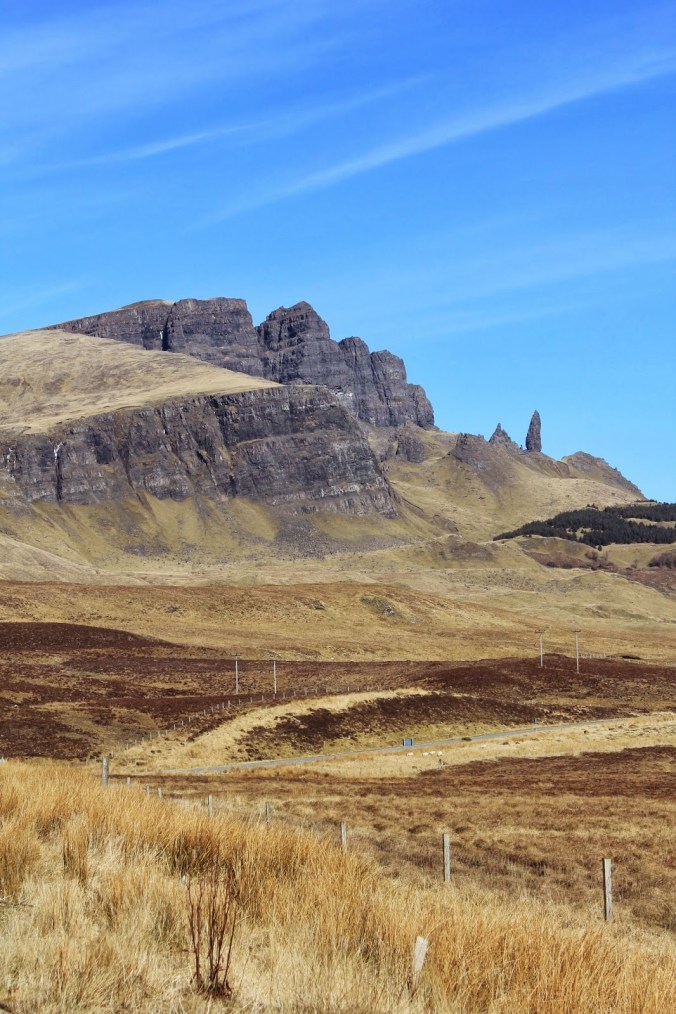
Here we left the “main” road and take the tuning to Dunvegan tonights overnight stop; following a brief climb over the top of the island we dropped down to Loch Harport and called in at the Talisker Distillery for a nosy (sadly no sampling of the famous fire of Skye was thought sensible given our mode of transport) and to grab a bite of lunch.
Feeling suitably refreshed we tackled the final climb of the day which although not hard still took some time due to the requirement for frequent stops to enjoy the staggering view of the whole of the Cuillin ridge laid out in the background. With its covering of snow and under blue skies it looked in absolutely perfect condition for a prized winter traverse in what is certainly the finest mountaineering experiance possible in the UK.
After I’d tired Lisa out with repeated photo stops we finally managed the short dash down into Dunvegan, where despite putting 80km under our wheels we have made much faster progress than expected and needed to wait a while before we could get into our accommodation. Fortunately it did not turn out to be a significant problem as Dunvegan conveniently was home to what I can only say is perhaps the best cake shop in the world which kept us busy and ensured full recovery from the days exertions.
The Cuillin from the Road to Dunvegan
Day 2: Dunvegan to Uig
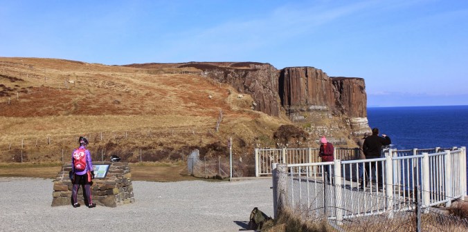
Day two began with an out and back ride down the dead end road from Dunvegan to Neist Point, a favourite location for photographers and an image I wanted to try and capture for myself. The point itself is a narrow headland of towering cliffs jutting out into the sea, a solitary lighthouse seemingly perched on the tip dwarfed by its setting.
The road to Neist was rough and rose up and down like a roller coster, the wind was also freshening, not too strong but bitterly cold if you stopped for long. We made good progress, but on arrival the sky was grey with no real colour in the scene, or a good horizon to really spark the view. Lisa went and hid from the wind whilst I messed around with my camera for a few minutes before beating a retreat; lycra is not the best clothing for landscape photography.
Despite the less than perfect photogenic conditions, the view is as spectacular as the photographs which have sat on my wall for years suggested, not just out over the point itself but also looking along the cliffs to the south, which are even higher than those of the point as the high rolling moorland plunges into the sea. Its a shame the light did not really allow me to do the view justice.
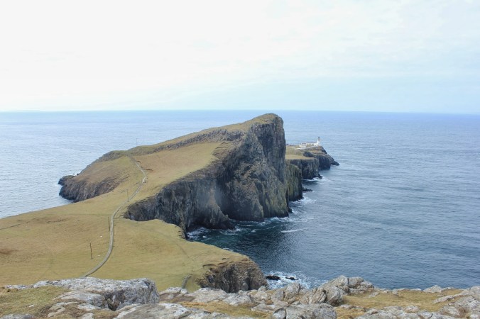
Neist Point and Lighthouse
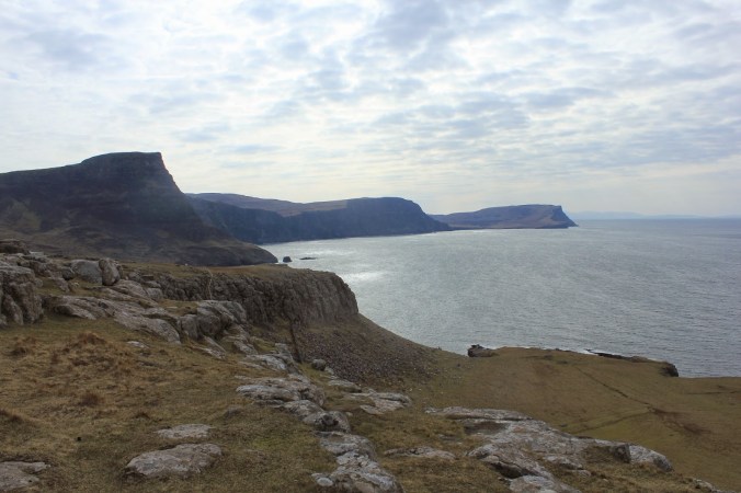
Looking south along the coast at the gargantuan cliffs facing the sea
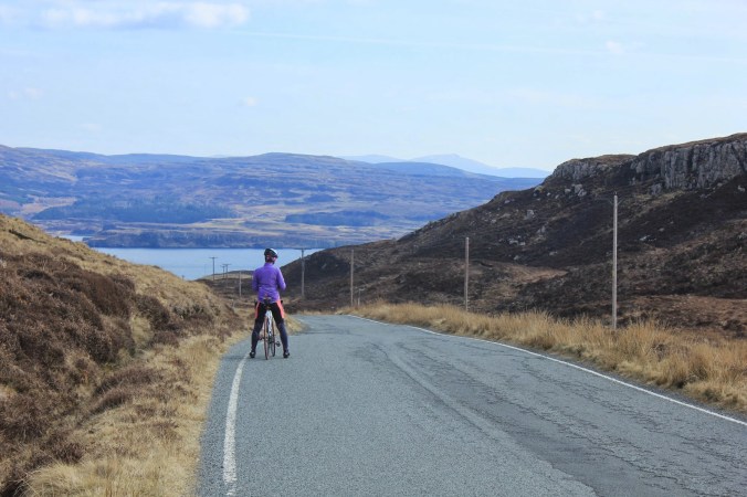
Returning from Neist we grabbed an early lunch before starting to work our way round the north east of the island. Dunvegan is dominated by the view out over the loch to two flat topped mountains called MacLeods tables, probably decapitated by some great ice scythe of ice 10,000 years ago. As we climbed out of Dunvegan they slowly receded behind us, the surrounding landscape a flat expanse of heather, dull compared to the scenery we were treated to the day before.
This being a main road for Skye the surface is generally good and we sped on past small plantations of trees which shelter the odd white painted house from the fury of the winds which must barrel across this landscape in winter. In the distance a line of turbines rotated slowly drawing power from the atmosphere, and right on the horizon the Cuillin flitted in and out of view behind the now gently rolling landscape.
After about 42km we swing right and join the A87 which works its way up the west coast of the Trotternish peninsula. The land is a massive bedding plane right the length of the peninsula dipping towards the west giving this coast a much gentler profile than the geological fireworks of the east coast we would traverse the following day.
On the road back from Neist Point
Lisa looking towards on of MacLeods Tables
The youth hostel in Uig sits high above the village with a quite stunning view out over the bay. The sunset in the evening is breathtaking, high cirrus clouds lit with yellows pinks, and oranges with a lower band of clouds sitting on the horizon coloured a deep blue and purple. The lights of the ferry port twinkle below the dark headland which shelters the bay.
Sunsets by the sea always seem special, the memorable ones in my mind are all associated with the big vistas you get looking out from the coast. Tomorrow should be as special day on the bike as we turn and head south along the geological bonanza that is the east coast of the Trotternish.
Distance for the day 82km.
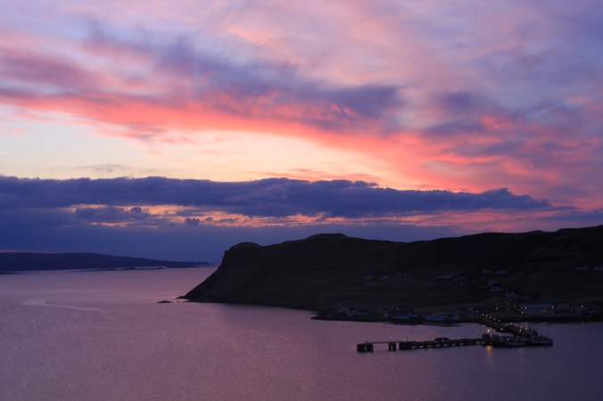
Sunset in Uig
Day 3: Uig to Broadford
When I first planned this trip the third day had been the exciting one, finally getting to visit the east coast of the Trotternish. During my previous visit to Skye I had caught glimpses of the Trotternish from afar, a great line of eastward facing cliffs, and the narrow needle of the Old Man of Storr flitting in and out of view on the horizon, familiar from a hundred pictures, and a favourite of Hollywood cinematographers looking for otherworldly landscapes. Day three would take us up and over the peninsular before diving down a great gash in the escarpment and traversing along beneath it on what mush surely be one of the great stretches of road in the UK.
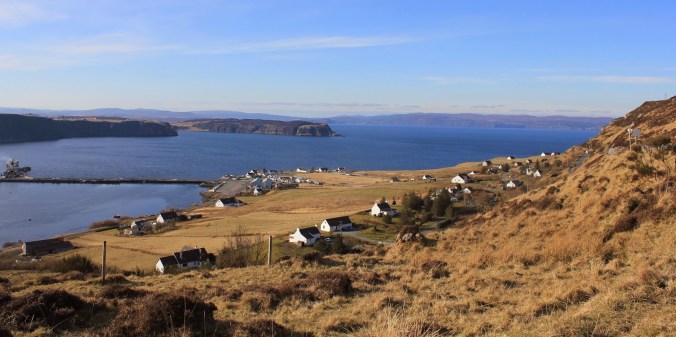
Looking back towards Uig
The day started straight out the blocks with a tough little pull uphill out of Uig as we clambered up on to the moorland via a couple of switchbacks, the gradient then lessened as the road turned inland climbing steadily to the horizon. Again the weather was cold but brilliantly clear with a deep blue winter sky over a calm sea which appeared to glow in the sunlight, and also very little wind to pit ourselves against. Easily distracted I spent my time stopping regularly to take pictures (this is a perennial grip of all my walking/climbing/cycling companions) looking back out to sea and Lisa soon pulls out a big lead.
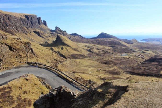
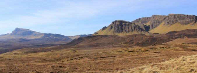
The single track road winds its way through a landscape of open moreland with no hit of the geological bonanza that awaits us just over the horizon. The winter chill that still permeate the land is evident from the brown and yellow hillside coated with a thin frost, and the icicles clinging to the vegetation where the road cuts into the earth. After about 45 min of steady climbing the edge of the plateau begins to appear, the moorland falls sheer for a hundred meters or more in a great line of black cliffs leaving isolated pillars of rock like crazy ruined castles of some long forgotten norse gods, towers pointing skywards.
Looking north along the escarpment
The small car park at the top of the pass must have one of the finest views in the UK, a celebration of what our planet and the slow but inevitable tick of the clock of deep time can do can do given enough time and energy. The view is almost other worldly and slightly mythical no wonder the place is a favourite for film and TV crews. For the cyclist there is also the thrill of what is to come; the road a narrow line of tarmac drops away sweeping steeply down through a weak point in the cliffs then straightening to charge towards the sea.
Once through the initial twisty section it is easy to build speed, and the dial easily hits seventy which is fast enough on a slightly rough surface. My new bike had been a joy to ride so far, dancing up hills and felt really nimble on the decent. The wind chill from such a rapid decent is terrific however especially in cold temperatures, and once we arrived at the junction with the main road it was decided a trip to a tea shop was in order.
Looking south
Geology Lesson
Freshly warmed up with tea and biscuits (always an essential part of any good ride) we began to follow the coast road south towards Portree. The escarpment runs along side our route to the west although it occasionally disappears behind the lower rolling coastal hills and forestry plantations.
The view of the Trotternish’s most famous landmark the Old Man of Storr are quite poor from the road either blocked by mounds of grass or merging with the massive cliffs in the background. The best views were from further afield where the Storr stands in sharp profile against the blue sky. The quite road briefly turns into a busy tourist trap around the parking for the Old Man of Storr; but with nowhere safe to leave the bikes and little enthusiasm to lug them up the hill to get a close up we pressed on and enjoyed the fast sweeping decent down into the town of Portree.
The Old Man
The Open Road
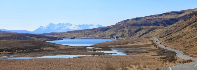
From Portree the remainder of the day was a simple traverse over to Sligachan with the Cuilin forever growing in grandeur ahead of us until we rejoined our road of two days previously. Although we planned to stay at the inn the thought of the short tip back to Broadford the following day seems a bit pointless so putting the peddles hard down we dash back to collect the car.
The following day for a rest we popped up a nearby hill to take in some amazing views of the Cuillin, bikes where not involved.
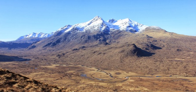
The Black Cuillin
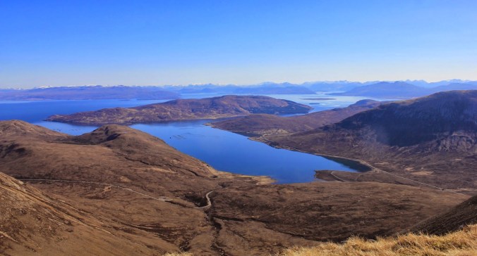
Looking towards the mainland
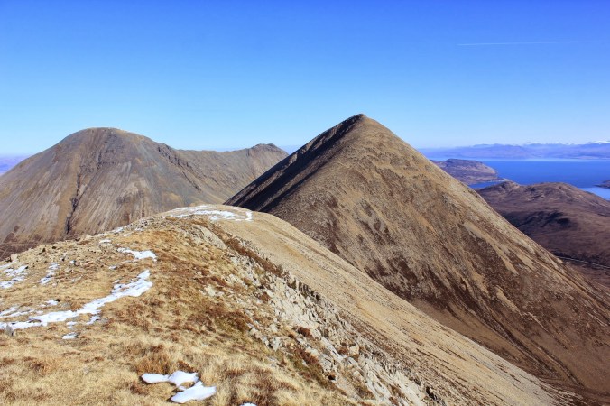
The Red Cuillin
