Despite being the middle of August it had been a chilly night in the Jotunheim, clear skies causing temperatures to fall uncomfortably close to the transition limit of my summer sleeping bag, and leaving me thankful for the warmth of my down mattress. Over a warming morning coffee to get the blood flowing, I checked the ferry times for what must have been the fifth time, running over the calculations in my head again convincing myself that todays hike would not end with me stuck at the far end of a lake with no way of getting back to my tent.
The ferry which runs up and down Lake Gjende is crucial to completing Norway’s most popular hike, the Besseggen Ridge in a day. The ridge forms the highlight of a 15km route that runs high above the northern edge of the lake between the DNT (Norwegian Treking Association) stations at Gjende and Memurubu. Unlike most hikers who catch an early boat to start of the hike at Memurubu, I had decided to take the slightly more risky option and walk the other way, meaning I was relying on catching the last ferry back to base; going this way did however offer the best views and allowed me to tackle the ridge in decent.
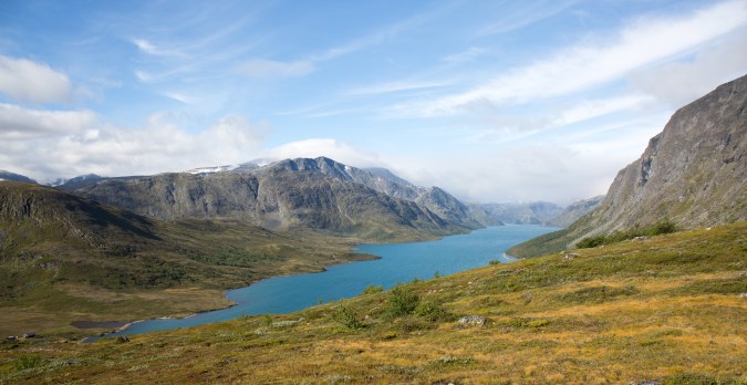
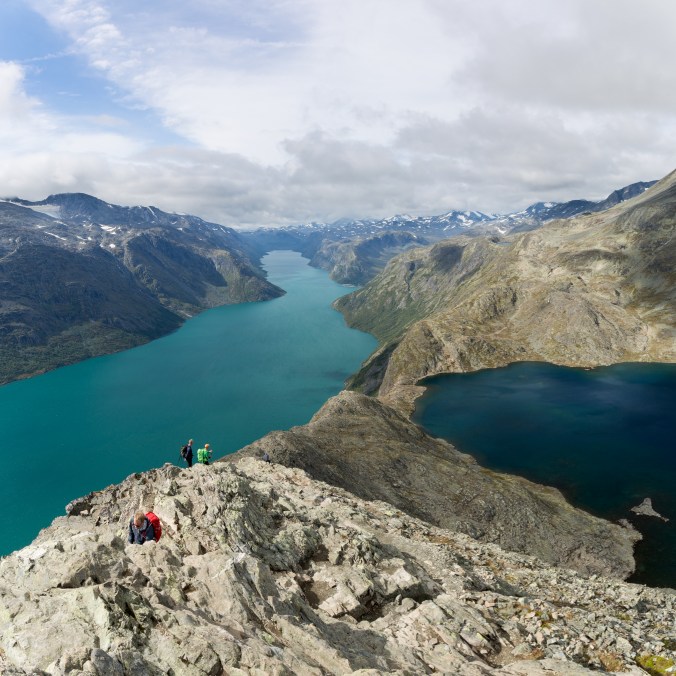
Lake Gjende
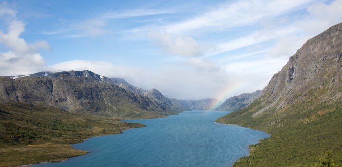
Rainbow
The bustle of the DNT tourist station was quickly hidden as the trail weaved its way steeply up the hillside; a fresh wind causing streamers of white to dance over the surface of the blue lake, blowing in a squall of rain to cast a rainbow against the distant clouds. The lake itself stretched into the far distance and narrow sliver of blue nestled between steep mountains, cliffs and crags.
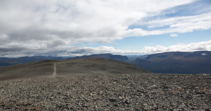
The Jotunheim contains more mountains above 2000m than anywhere else in northern Europe and reminded me very much of the Cairngorms but on a much large scale. As hight is gained above the valley floor the trees and bushes give way to grass and moss, before these too give up the struggle against the elements leaving just lichen to splash itself over the carpet of shattered rock; its a testament to the harsh conditions against which life must fight this far north. Besieger’s summit is a gently undulating plateau offering great views over the peaks which surround it on all sides, with snow patches and small glaciers plastered to the flanks of the higher mountains.
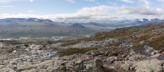
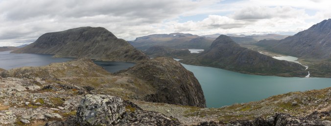
Looking over the Jotunheim
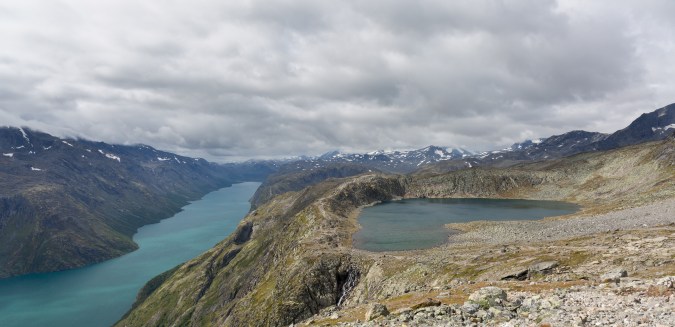
The summit plateau
The plateau gradually narrowed, becoming hemmed in by steep cliffs on both sides, the ridge however remained hidden until the last minute with the view ahead dominated by the bulk of the peak of Besshoe. Then suddenly the ground vanishes before you, plunging downward towards a hanging valley filled by a lake who’s dark blue waters contrast vividly with the turquoise of Lake Gjende. The lakes, although seemingly only a good stone throw apart are actually separated by something between 200 to 300m difference in altitude.
It’s a fantastic view fully justifying the walks popularity, although how much the ferry load of people who I ran into at this point hiking east from Memurubu got to appreciate it I’m not sure, as whilst climbing up the ridge the best view is to their backs. Technically the decent was pretty easy, the ridge is not as narrow or exposed as many of the UK classics such as Crib Goch, or possibly even Striding Edge and I only need to use my hands fleetingly at the steeper sections.
The view from the start of the ridge
Looking back at the ridge
Although the highlight of the route the walk is far from over once you get off the ridge, you are actually only about half way to Memurubu although the path from here is easy to follow and contains no real further difficulties as it weaves its way over the shoulder of Besshoe. The terrain in the second half of the hike is more varied weaving up and down giving constantly changing views out over Gjende and into the more remote higher mountains deep in the interior of the park. The landscape is expansive, a network of rivers, lakes and waterfalls, looking back the Besseggen ridge looks sharp, prominent, and inviting.
As the afternoon wore on cloud began to build and shrouded the tops of the higher peaks and I was relieved to have caught the best of the weather for the most picturesque section of the hike. As I approached Memurubu a series of signs warn hikers travelling the other way (east) that if they have taken more than a certain amount of time to get here they should turn around and head back otherwise they risk not finishing before nightfall. AS I don’t pass anyone on the remainder of the hike I can assure that the signs either work or the Norwegians are all far to fast to ever get caught out like that.
The decent to the DNT station is steep and actually quite unpleasant with lots of loose rock to slip on, its eroded to the extent it would almost certainly get fixed if it were in the UK, but from my limited experience of hiking in Scandinavia, heavily engineered paths are uncommon.
Making good time I arrived well over an hour before the ferry was due so was able to have a good look round the station which comprised a series of huts including a restaurant (where I’m sure I could buy a very expensive beer), and a lovely campsite down by the waters edge. For walkers heading west therefore missing the ferry would not be a complete disaster as food and accommodation is available. For me though, I have a date with some Swedish beer back at the campsite (having been advised to stock up before crossing the border and thus avoid having to take out a small loan to buy alcohol in Norway)!
A small tarn by Norwegian standards
